Stuarts Point groundwater update #7
Published on 30 March 2022
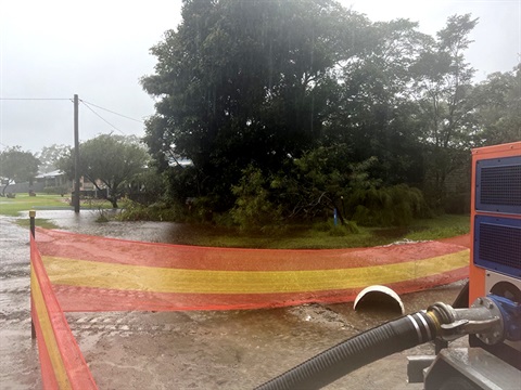
Significant rainfall has occurred over the past 24 hours and is expected to continue today.
Pumping operations to assist with drainage commenced on Third Avenue and Ocean Avenue Tuesday morning with 4 pumps now operating.
The pumping has been successful and will continue for the foreseeable future to assist in maintaining surface water levels.
Groundwater levels have sharply risen overnight, contributing to surface water in and around Stuarts Point.
Council inspectors are monitoring onsite sewage management systems in key areas. Water quality testing is also being undertaken.
There is an ongoing risk of groundwater reaching surface level in more locations in Stuarts Point in a similar way to the Flood Event of March 2021, as previously reported.
If you need emergency help with flooding in your property call the NSW State Emergency Service on 13 25 00. In life-threatening situations call triple zero (000) immediately.
Toilets open
If groundwater is covering household septic tanks, residents are advised to minimise use of water in your homes, especially showers and toilets.
Stuarts Point Holiday Park are opening their amenities blocks for impacted residents. Any resident needing to use the showers should park in the foreshore public car park and go to reception who will give directions and the access code.
Toilet blocks at the sports fields and foreshore have also been opened.
Current levels
Groundwater levels at Bore 1 have risen sharply overnight, recording approximately 0.4m in the last 14 hours and are approximately 0.32m below the level seen in March 2021 Flood Event.
The Bureau of Meteorology has issued a Minor to Moderate Flood Warning for the Macleay River as well as a Severe Weather Warning for the northern parts of the Mid North Coast.
Council are in constant contact with other key agencies to ensure a full response to any and all situations.
Council staff and emergency services are monitoring the situation on the ground and through groundwater level monitors.
Residents should monitor conditions at their own properties and act accordingly.
Readings taken at 6am Wednesday 30 March 2022.

How to read this diagram
The diagram shows the groundwater level for the past 30 days. The three graphs essentially present the same data but each with relation to a different reference point (or datum).
- The blue graph shows the depth of water below the Mount Point, which is where the laser that takes the reading is mounted.
- The red graph shows the height of the water above the Australian Height Datum (AHD) which is the official height metric based on the average of sea levels from 1966-68.
- The green graph shows the depth of the water below ground level at the location of the meter.