Macleay Valley Flood Update #18
Published on 01 April 2022
KEMPSEY SHIRE COUNCIL FLOOD UPDATE #18
FINAL UPDATE SATURDAY 2 APRIL
This page is no longer being updated. For updates on Roads and Bridges head to www.ksc.pub/roadsandbridges
Update 7.30am Saturday 2 April
Crescent Head Road at Rudders Lagoon is now open.
Crescent Head Road at the corduroy remains closed.
Update 7.30pm Friday 1 April
Turners Flat Bridge is now open.
Update 6pm Friday 1 April
The NSW SES advises you may now return safely to the following areas:
• Belmore River
• Smithtown
• Gladstone
• Kinchela
• Jerseyville
• Rainbow Reach
• Summer Island
KEY CHANGES
- The Bureau of Meteorology has issued a Final Flood Warning for the Macleay River - Flood Warning - Macleay River (bom.gov.au).
- Flooding is no longer expected at Kempsey and Smithtown.
- The flood relief gates on the Belmore River and Kinchela Creek are now CLOSED.
- The Macleay River level continues to fall however key routes are still impacted by water over the road or arr closed.
- An evacuation warning is still in place for Stuarts Point.
- Crescent Head and parts of South Kempsey on Crescent Head Road are currently isolated due to the closure of Loftus Road at Belmore River and Crescent Head Road at the Corduroy and Rudders Lagoon. This may last several days.
- Water pumps are still operating in Stuarts Point to lower groundwater levels.
- Bridges that cross the Macleay River upstream of Kempsey are expected to start opening Friday evening and into Saturday.
- Damage to road and bridges may cause delays in opening roads, please be patient as staff undertake inspections and repairs.
FLOOD WARNING
The Bureau of Meteorology has issued a Final Flood Warning #18 for the Macleay River at 1.19pm on Friday 1 April 2022.
The warning states:
- No further flooding is expected along the Macleay River.
- The Macleay River at Kempsey (AHD) fell below the minor flood level (4.50 m) around 07:30 am Friday and is currently at 4.06 metres and falling.
- The Macleay River at Smithtown fell below the minor flood level (3.40 metres) around 2:00 am Friday morning and is currently at 3.06 metres and falling.
- This is a final warning, no further warnings will be issued for this event.
For up-to-date warnings head to Flood Warning - Macleay River (www.bom.gov.au/nsw/warnings)
STUARTS POINT
An evacuation warning is still in place for Stuarts Point.
Groundwater levels are still rising due to heavy rain and multiple properties are flooded.
There are multiple water pumps operating in Stuarts Point to try to lower groundwater levels.
If water is covering household septic tanks, please minimise use of water, especially showers and toilets. Stuarts Point Holiday Park and Grassy Head Holiday Park have opened showers and toilets for impacted residents. Toilets blocks at the sports fields and foreshore have been opened.
Recovery is now a focus for impacted properties and residents. This includes assessments and disinfection where required.
For more info, head to Stuarts Point groundwater update #8 (www.ksc.pub/stuartspoint8)
RIVER LEVELS AND TRENDS
Below are levels and trends of the Macleay River:
- Toorooka - 4.87m at 11.46am - FALLING - 4.61m at 3.34pm
- Turners Flat - 4.94m at 11.30am - FALLING - 4.64m at 3.30pm
- Sherwood Bridge - 4.82m at 9.44am - FALLING - 4.41m at 1.39pm
- Kempsey Traffic Bridge - 4.17m at 11.39am - FALLING - 3.84m at 3.45pm
- Smithtown - 3.15m at 11.15am - FALLING - 2.86m at 3.15pm
NOTE: Georges Creek and Bellbrook gauges have been removed as they are consistently falling.
Residents can monitor river levels on the Bureau of Meteorology's website (www.bom.gov.au) and act accordingly.
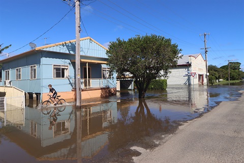
DRIVING CONDITIONS
Please do not take unnecessary risks and do not drive through floodwaters.
If you are in a known flood-prone area, we encourage you to note the current conditions and decide if you should implement your flood plan.
Roads, bridges and drainage infrastructure could be damaged in several locations. If you are travelling, exercise great caution.
RIVER CROSSINGS
We have received the following updates for bridges that cross the Macleay River upstream of the Kempsey Traffic Bridge:
- Bellbrook Bridge is CLOSED
- Toorooka Bridge is CLOSED
- Temagog Bridge is CLOSED
- Turners Flat Bridge is CLOSED
- Sherwood Bridge is CLOSED
- Dungay Creek Causeway is CLOSED
- Dowling’s Falls Causeway is CLOSED
NOTE: Bridges are expected to start opening Friday evening and into Saturday.
Please do not cross any bridges that remain closed, even if water has receded. There may be hidden dangers.
Council Staff will inspect the structure as soon as possible prior to opening.
CLOSED ROADS
At present the following roads have been marked as CLOSED:
- Crescent Head Road at the Corduroy is CLOSED
- Macleay Valley Way (Smith Street) – near Shell Service Station to Frederickton is CLOSED
- Belmore River Right Bank Road is CLOSED
- Belmore River Left Bank Road is CLOSED
- Kinchela Creek Left Bank Road is CLOSED
- Kinchela Creek Right Bank Road is CLOSED
- Armidale Road at Blackbird Flat to Forest Way within the Armidale Regional Council’s LGA area is CLOSED
- Euroka Road – at Theresa Street is CLOSED
- Hickeys Creek Road, Millbank is CLOSED
- Saleyards Road – at both ends is CLOSED
- Second Lane is CLOSED
- Gladstone Street underpass is CLOSED
- Maria River Road is CLOSED
- Wide Street below Showground is CLOSED
- Collombatti Road - near the tea tree farm is CLOSED
- Seale Road is CLOSED
- Old Aerodrome Road is CLOSED
- Bloomfield Street is CLOSED
- Nicholson Street/Macquarie Street – at intersection is CLOSED
- Old Station Road is CLOSED
Note, key routes are impacted including Belmore River Right Bank Road, South West Rocks Road, Loftus Road, Hat Head Road, Crescent Head Road, Plummers Lane, the Macleay Valley Way and Smithtown Road. Water is likely over the road in several locations and closures are in place.
Crescent Head and parts of South Kempsey on Crescent Head Road are currently isolated due to the closure of Loftus Road at Belmore River and Crescent Head Road at the Corduroy and Rudders Lagoon. This may last several days.
OPEN ROADS
The following roads are now OPEN, but this could change and motorists should proceed with caution
- Crescent Head Road at Rudders Lagoon is OPEN
- Queen Street Causeway, South Kempsey is OPEN
- Eden Street is OPEN
- Stuart Street is OPEN
- South West Rocks Road between Red Hill and Gladstone is OPEN
- Macleay Valley Way between Frederickton and Plummers Lane is OPEN
- Plummers Lane is OPEN
- South West Rocks Road between Gladstone and Jerseyville is OPEN
- Summer Island Road is OPEN
- Smithtown Road is OPEN
Please note, there is WATER OVER THE ROAD in several locations:
- Grassy Head Road near the access road to Middle Head Beach
- Beranghi Road
- Verges Creek Road
- Macleay Valley Way at Plummers Lane turn off
- Fishermans Reach Road, 50 metres south of Barnetts Trail
Damage to bridges and roads may case delays in opening. Please be patient as Council inspects and repairs.
Check our Facebook page, website, www.livetraffic.com or 13 27 01 for road status information.
FLOODGATES
Council closed all floodgates on Saturday. Flood relief gates were opened on Wednesday afternoon. They were closed at 3am Friday.
- The floodgates on Kinchela Creek, Belmore River, Christmas Creek and Euroka Creek are CLOSED
- Flood relief gates at Kinchela Creek and Belmore River are CLOSED.
- Ryan’s Cut Outlet is OPEN to the ocean.
- Big Hill Outlet is OPEN to the ocean.
SEWER
- In heavy or sustained rain events it is not uncommon to experience sewer overflows in our sewer catchment areas. These are often not preventable, as sewerage systems are not designed to transport stormwater in these events.
- Our teams continue to monitor the situation and conduct sampling, reporting and clean-up in these areas.
FLOOD CAMERAS
The most recent images from flood cameras on the Macleay River are available at ksc.pub/floodcameras (Kempsey Traffic Bridge now working again)
The flood monitoring camera at Sherwood Bridge, west of Kempsey, is focused on the bridge deck so residents can see if the bridge is being affected by flooding.
Images are updated every 30 minutes. Please note the time stamp is set to Australian Eastern Standard Time NOT to Australian Eastern Daylight Saving Time.
WHAT SHOULD YOU DO?
Council urges you to:
- Be cautious on the roads and DO NOT attempt to drive through floodwaters or cross flooded bridges.
- Consider the impact of possible road closures and flood isolation on work, family and educational commitments
- Monitor emergency warnings and severe weather updates
- If your property is at risk of flooding, please raise moveable items, such as furniture, as high as possible onto benches or tables, placing electrical items on top
- If you live in a low-lying area and are advised by an emergency services officer to evacuate, please do so
- Secure outside belongings and before leaving, turn off the power and water and take pets, essential medicines and clothes with you
COUNCIL SERVICES AFFECTED
Flood events can affect a number of Council services including sports fields, waste centres and libraries.
Please consult our list of impacted services.
COUNCIL CREWS MONITORING THE REGION
Council's work teams are inspecting roads and areas of concern and we will advise you of developments in future updates.
Council staff are currently stretched and flood damage could be present in several locations. If you need to travel please exercise caution.
Council welcomes advice from residents in outlying areas. You can report concerns to Council on 6566 3200 but our Customer Service Centre is currently experiencing a high volume of calls so please check that your concerns have not already been addressed online.
For emergency help in floods and storms, call the NSW State Emergency Service on 13 25 00. In life-threatening situations call triple zero (000) immediately.
FOR MORE INFORMATION
- Check Council's automatic Disaster Dashboard at ksc.pub/disasterdashboard
- Listen to local ABC radio, the emergency broadcaster, on 95.5 FM or 684 AM
- Follow NSW SES on Facebook or www.ses.nsw.gov.au
- Latest weather, warnings, rainfall and river heights: www.bom.gov.au/nsw
- Road closures and traffic info: RMS www.livetraffic.com or 13 27 01
NEXT UPDATE
We will post updates to our website and Facebook page as information becomes available.
This is the final formal update. Future updates will focus on roads and bridges. Evacutation information and Stuarts Point updates will also be shared.