Chapter F1: Stuarts Point
1 - Introduction
1.1 Scope of this Chapter
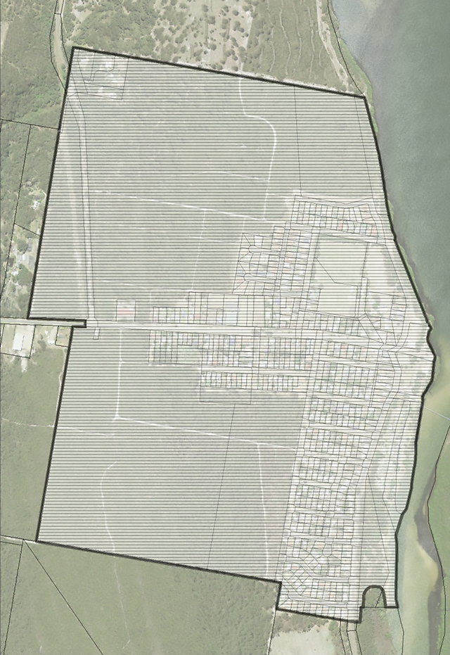
This chapter applies to all development on land within the area of Stuarts Point village located within Zone RU5 - Village and Zone IN1 - General Industrial, as shown outlined in bold line in the figure below.

Figure F1-1: Map - Land subject to the provisions of Chapter F1
1.2 Relationship to Other Chapters of this DCP
The provisions of this Chapter override the provisions of any other Chapter of this DCP, to the extent of any inconsistency.
2 - Chapter Objectives
The objectives of this Chapter are:
- To provide the planning policy framework for enhancing and maintaining residential, commercial and industrial development within the village of Stuarts Point.
- To identify, enhance and protect the key elements which comprise the present character of Stuarts Point without removing the incentive for development.
- To promote urban consolidation through the encouragement of high quality medium density development.
- To ensure that investigations are carried out in relation to particular large holdings within the village of Stuarts Point prior to further development proceeding.
3 - Relationship to Other Documents
Kempsey Local Environmental Plan 2013 contains certain requirements that will apply to development in Stuarts Point. The development requirements of this Chapter should be addressed in conjunction with the relevant requirements of KLEP. A copy of KLEP2013 is available on Council’s website.
Some Council Policies will apply to development in Stuarts Point. A copy of Council Policies is available on Council’s website.
Development Contributions will be triggered by development applications, through:
- Current Section 94 Contribution Plans; and
- Current Section 64 Development Service Plans.
A copy of Council’s Contributions Plans are available on Council’s website and will need to reviewed to determine their applicability to each development application. Current fees and charges may be calculated by applying annual CPI to the listed contribution rate, or by contacting Council.
The following State Environmental Planning Policies (SEPPs) are considered to be the most relevant to Stuarts Point and should be reviewed and the relevant requirements addressed in any development application for development, including subdivision, in Stuarts Point. Other SEPPs should be reviewed as relevant:
- SEPP (Affordable Rental Housing) 2009;
- SEPP (Exempt and Complying Development Codes) 2008;
- SEPP (Infrastructure) 2007;
- SEPP (Housing for Seniors or People with a Disability) 2004;
- SEPP No.71 - Coastal Protection;
- SEPP No.62 - Sustainable Aquaculture;
- SEPP No.44 - Koala Habitat Protection; and
- SEPP No.14 - Coastal Wetlands.
4 - Precincts in Stuarts Point
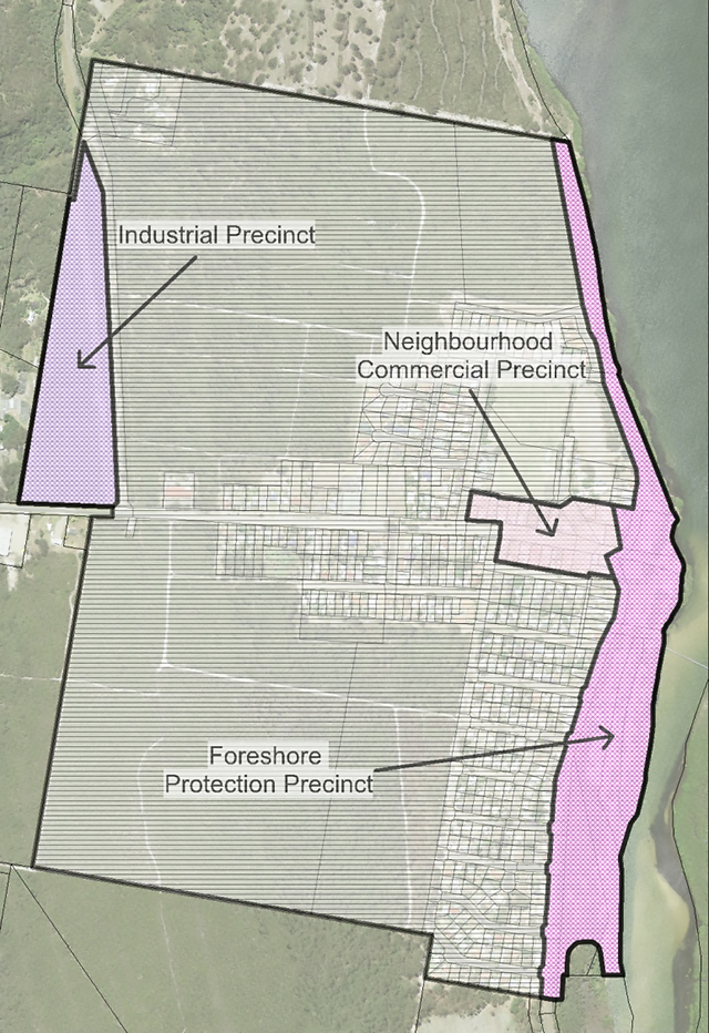
Stuarts Point is divided into the following precincts, as depicted in the following figure, for the purposes of this Chapter:
- Industrial Precinct;
- Neighbourhood Commercial Precinct; and
- Foreshore Protection Precinct.

Figure F1-2: Map - Precincts in Stuarts Point
5 - Development Requirements
5.1 Commercial Development
Desired Outcomes
DO1 - Commercial development is consolidated into the Neighbourhood Commercial Precinct.
DO2 - Commercial development contributes to the establishment of a future integrated shopping complex.
DO3 - Single neighbourhood shops are accommodated throughout the village.
DO4 - Commercial development complies with the relevant requirements of:
Development Requirements
5.1.1 Neighbourhood Commercial Precinct
- Development for the purpose of commercial premises, not being an “integrated shopping complex”, are to be generally confined to within the “Neighbourhood Commercial Precinct”.
- The design of buildings within the Neighbourhood Commercial Precinct is to be compatible with the existing architectural character of Stuarts Point.
- Sufficient details are to be submitted with Development Applications to enable Council to fully evaluate the proposed appearance of buildings.
- Carparking and service vehicle delivery areas are to be provided on site, in accordance with Chapter B2 - Parking, Access and Traffic Management.
5.2.2 Integrated Shopping Complex
- The provision of a minimum of 2000m² of commercial gross floor space, incorporating a supermarket and specialty shops, within the “neighbourhood commercial precinct”.
- Parking is to be provided on site at the rate of one (1) space per 20m² of gross floor space for the supermarket component and one (1) space per 35m² of gross floor space for specialty shops.
- Adequate provision is to be made for the incorporation of existing trees in a manner which will ensure their long-term survival.
- A plan of survey prepared and endorsed by a registered surveyor is to be submitted with Development Applications identifying the location of all trees on site.
- Building design is to be compatible with the existing architectural character of Stuarts Point.
- Pole signs are not to exceed 6.2 metres in height and shall not contain advertising signs other than business identification signs.
- Applications are to be accompanied by a traffic study prepared by a qualified engineer, indicating that proposals will not have any long term or short term adverse impact on traffic movements in the area.
- Adequate provisions are to be made for the disposal of effluent, such that no adjoining property will be adversely affected.
- Provision is to be made for connection to Council’s sewerage system when services become available.
5.1.3 Neighbourhood Shops
Council will give consideration to proposals for shops outside of the Neighbourhood Commercial Precinct (not being an integrated shopping complex) provided the following criteria have been met:
- The store is to comply with the definition of “neighbourhood shops” under the provisions of Kempsey Local Environmental Plan 2013.
- The neighbourhood shop is to comply with the requirements of clause 5.4(7) of KLEP2013.
Note - At the time of adoption, clause 5.4(7) required that the retail floor area of neighbourhood shops not exceed 120 square metres.
- No more than one (1) such store is to be contained within the building.
- Council is to be satisfied that the proposal will not reduce the viability of the Neighbourhood Commercial Precinct.
- The proposal must not reduce the amenity of any adjoining residence.
5.2 Residential Development
Desired Outcomes
DO1 - Residential and tourist accommodation is the dominant form of development within the village.
DO2 - Development does not have an adverse impact on visually sensitive areas.
DO3 - The economic provision of public services is promoted through:
- The prevention of premature and sporadic subdivisions; and
- ensuring that subdivisions and new development take the form of consolidating existing urban areas.
DO4 - Subdivision has adequate regard for existing environmental constraints, such as maximising the preservation of significant flora and fauna.
DO5 - On-site Sewage Management Systems are provided to serve the needs of development and satisfactory arrangements are made for any future connection to a sewer system.
DO6 - Residential development complies with the relevant requirements of Chapter C1 - Residential Development, in addition to the following development requirements.
DO7 - Local parks are provided in accordance with the relevant provisions of Chapter B1 - Subdivision (Section 13.0), in addition to the relevant requirements in this section.
Development Requirements
5.2.1 Location Criteria
- Residential development, including residential subdivision, is to demonstrate consideration of the future amenity of residents, having regard to the proximity of existing and future commercial and industrial development as well as the proposed sewerage treatment plants.
5.2.2 Design Criteria
- The design of new development is to be compatible in terms of height, scale and form with the design of adjoining buildings and buildings within the locality.
- Buildings fronting Marine Parade are to be:
- designed so as to minimise their visual impact on the adjoining reserve and the Macleay River;
- constructed of materials which are of a low reflective colour and which compliment the natural colours found in the adjoining reserve; and
- screened from Marine Parade by densely planted landscaping consisting of species that occur naturally in the locality.
5.2.3 Residential Subdivision
- Subdivision for residential purposes shall only occur on land located immediately adjacent to existing or approved residential subdivisions.
- Existing land holdings shall not be subdivided where fragmentation is likely to prevent the orderly and economic future subdivision of land for residential purposes.
- Development for residential purposes will not be approved unless adequate regard has been paid to the likely impact on flora and fauna.
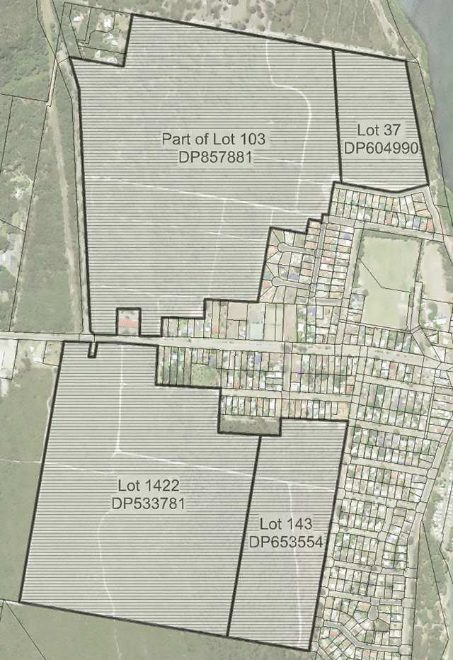
- Council will not approve of any plan of subdivision of:
- Lot 1422, DP 533781, Ocean Avenue;
- Lot 143, DP 653554, Second Avenue;
- Lot 37, DP 604990, Kimpton Street; or
- Lot 103, DP 857881, Grassy Head Road.
Unless:
- a comprehensive drainage strategy has been formulated for all affected lands including the relationship with the proposed subdivision and all proposed drainage works;
- Council is satisfied that each proposed lot is connected to a sewerage system or satisfactory arrangements have been made for the future provision of a sewerage service to each lot;
- a detailed study of native flora and fauna has been carried out by a suitably qualified ecological consultant identifying areas of native habitat to be retained;
- a statement as to the likely impact on any flora and fauna identified as endangered or threatened under the:
- National Parks and Wildlife Act 1974;
- Threatened Species Conservation Act 1995; and
- Fisheries Management Act 1994; and
- means that are to be employed to minimise any such impact.
- a traffic stuffy prepared by a suitably qualified Traffic Engineer has been prepared which identifies a road hierarchy strategy and the relationship of the proposed subdivision to that strategy including provision for a proposed Tourist Drive linking to the south.

Figure F1-3: Lots affected by specific subdivision requirements
5.2.4 Provision of Local Parks
- In addition to the matters identified in Section 13.0 of Chapter B1 - Subdivision, any Open Space Management Strategy submitted with a residential subdivision application is to demonstrate compliance with the following requirements:
- Areas required for drainage shall be dedicated as drainage reserve and shall not be offset against land required to be dedicated for open space;
- Areas required for habitat protection, excluding land required for drainage purposes, may be offset against land required to be dedicated for open space provided adequate useable open space has been provided in the vicinity;
- Areas required to provide for bushfire trails and radiation buffers shall not be offset against land required to be dedicated for open space; and
- Land suitable for development for public recreation is to be provided such that 75% of new allotments are within 500 metres.
5.3 Foreshore Protection Precinct
Desired Outcomes
DO1 - Development within the “Foreshore Protection Precinct” has a very minor visual and environmental impact on the precinct.
DO2 - The “Foreshore Protection Precinct” is preserved in its natural state, as far as is practicable.
Development Requirements
- The “Foreshore Protection Precinct” is to remain largely in its existing state.
- Any buildings erected within the existing caravan park are to be designed so as to minimise any visual impact and are to make provision for suitable landscaping.
- Any landscaping required for buildings within the “Foreshore Protection Precinct” is to incorporate native species similar to those naturally occurring in the locality.
- Buildings, other than those required for the caravan park, are to be restricted to picnic shelters of open timber pole construction.
5.4 Industrial Development
Desired Outcomes
DO1 - Industrial development occurs in a manner that will not detract from the amenity of existing and future residents.
DO2 - Potential traffic conflict is reduced.
DO3 - Development has minimal impact on the visual and environmental amenity of the locality.
Development Requirements
- Development for the purpose of industrial activity, and like uses such as vehicle repair stations, is to be generally confined to land zoned IN1 - General Industrial.
Note - Industrial Development is prohibited in Zone RU5 - Village
- A strip not less than 25 metres wide running parallel to Grassy Head Road is to be set aside as a scenic/visual buffer.
- Lands required for the scenic buffer between Grassy Head Road and the industrial area shall be retained by means of an appropriate Section 88B Instrument within the ownership of the land zoned IN1 - General Industrial. The Section 88B Instrument will be required for any development of the IN1 zoned parcel and shall specify that the care and maintenance of the area is to be the responsibility of the owners and that no trees are to be removed.
- Development of all lands zoned IN1 - General Industrial fronting Grassy Head Road is to provide for two (2) only points of access. Any proposed development shall demonstrate how access to future development via this single means of access can be achieved.
- The façade of buildings facing Grassy Head Road shall be of masonry brick construction.
- Landscaping is to be provided within the area fronting Grassy Head Road using native species which compliment the required scenic/visual buffer.