Chapter B7: Flood Hazard Area Management
1 - Introduction
1.1 Scope of this Chapter
This Chapter applies to all land within the Kempsey Shire local government area, which is identified on the Flood Planning maps on Council’s website and other land at or below the Flood Planning Level.
1.2 Relationship to Other Chapters of this DCP
The provisions contained in Chapters included in Parts C, D, E and F of this DCP override the provisions of this Chapter to the extent of any inconsistency.
This chapter of the DCP is to be read in conjunction with those sections of this DCP which specify flood related development requirements for individual land uses and specific areas.
1.3 Flood Mapping
Flood mapping defines flood levels, flood extents, flood velocities and floodways, and where available is used to determine flood behaviour within Kempsey Shire. This mapping is generally limited to urban areas and mainstream flooding areas on the Macleay River Floodplain below Aldavilla. These maps are updated from time to time to reflect the latest data and understanding of flood behaviour. Please see the Kempsey Flood Planning map.
1.4 How to use this Chapter
Where a development is proposed in respect of land to which this Chapter applies, Council will take the provisions of this Chapter in consideration in determining the application.
Compliance with the provisions of this Chapter does not imply that Council will grant consent to an application. Council must, in relation to development applications, also take into consideration those matters listed under Section 4.15 of the Environmental Planning and Assessment Act 1979.
2 - Chapter Objectives
The objectives of this Chapter are:
- To ensure that development on flood prone land is consistent with:
- Kempsey Local Environmental Plan 2013;
- Council’s adopted Floodplain Risk Management Plans;
- NSW Government’s Floodprone Lands Policy; and
- NSW Government’s Floodplain Development Manual.
- To ensure that new development on flood prone land is compatible with the degree of flood hazard and that adequate flood risk management measures are incorporated in the design of the development thereby minimising the possibility of loss of life and damage to property.
- To encourage the re-development of existing flood prone lands in a manner that will minimise the chance of loss of life and damage to property by future flooding.
- To prevent the creation of any ‘new area’ of urban development on flood prone lands.
- To prevent any extension of existing urban zoned areas into flood prone lands.
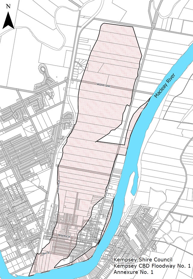
- To seek the eventual clearance of the Kempsey CBD Floodway Number 1 and its re-development for recreational, agricultural and limited commercial uses which will only have a minimal effect on the free flow of floodwaters and minimal risk of causing loss of life or damage to property, e.g. sporting fields, picnic grounds, nurseries, recreation facilities with minimal permanent buildings and no residential facilities.
3 - Guidelines
3.1 Floodplain Risk Management Plans
At the time of adoption of this DCP, related detail in relation to development on flood affected land are contained in Council adopted Floodplain Risk Management Plans.
3.2 Determining flood prone land
Land impacted by flooding can be identified in the Flood Planning maps on Council’s website. The provisions of this chapter will apply to development on or within the Flood Planning Area.
3.3 Determining the Flood Planning Level for a site
The Flood Planning Level for any locality on the Macleay River Floodplain is determined by identifying the 1% AEP Flood level (on Australian Height Datum) from the Council adopted flood record then adding a freeboard of 0.5 metres.
This level is used to set the minimum habitable floor level for residential buildings in the Kempsey Shire.
3.4 Definitions
For the purposes of this Section:
“1% AEP” (1 in 100 Flood) – Flood probabilities are expressed in terms of the chances of an event occurring or being exceeded in any given year. For example, a “1 in 100” or “1%” AEP flood has 1 chance in 100 of occurring, or being exceeded, in any one year.
“Annual Exceedance Probability (AEP)” means the chance of a flood of a given or larger size occurring in any one year, usually expressed as a percentage.
“Australian Height Datum (AHD)” means the common national plan of level corresponding approximately to mean sea level.
“Average Recurrence Interval (ARI)” is the long-term average number of years between the occurrence of a flood as big as, or larger than, the selected event.
“BCA” means Building Code of Australia.
“Critical Infrastructure” as per Floodplain Development Manual, Appendix K3.1.
“Critical Services” means emergency services facilities and hospitals as defined in KLEP 2013.
“Development” in relation to land, means:
- the erection of a building on that land;
- the carrying out of work, in on, over or under that land;
- the use of that land or of a building or work on the land;
- the subdivision of that land.
“Essential Community Facilities” means community facility as defined in KLEP 2013.
“Flood Fringe” are areas that do not play a significant role in either storing or conveying water.
“Flood Planning Area (FPA)” is the area of land below the flood planning level (FPL) and may also extend to include other areas of land where the majority flood related controls apply. FPA is as shown on the Flood Planning maps on Council’s website.
“Flood Planning Levels (FPL)” are the combination of the 1% AEP flood levels and 0.5m freeboard.
“Flood Planning maps” are the maps on Council’s website.
“Flood Prone Land” is land which is inundated by a 1% AEP flood.
“Flood Response Assessment Plan” provides a means by which a developer can assess and nominate the most applicable flood emergency response option for a habitable development, whether it be avoidance or evacuation, and for Council officers to consider during assessment of the development application.
NB. This plan is not intended to be a document that provides details for site specific management of flood preparation and response for a habitable development. Such private flood plans should be developed and implemented by owners and occupants following completion of the development. Information available on the NSW State Emergency Services (SES) website www.ses.nsw.gov.au may assist in the preparation of private flood plans.
“Flood Statement” is a written assessment of the nature of flooding at the site of the proposed development. It should contain details of flooding in relation to the development and details of how the information contained in the statement was obtained and any other relevant matters. The statement is to show that due regard has been given to the effects that development will have on the environment, including adjoining properties and land.
“Flood Storage Area” is an area that stores a significant volume of water.
“Floodway” is an area:
- which is a main flow path for floodwaters once the river or stream has overflowed;
- transmits large quantities of water;
- in which developments may adversely affect the behaviour or discharge of floodwaters;
- in which development may be adversely affected by the discharge of floodwaters, otherwise than by immersion;
- in which human life could be at risk from the discharge of floodwaters.
Floodways are identified on plans annexed to this Chapter.
“Habitable Room” includes any living rooms and any rooms intended or adaptable for sleeping, eating or cooking but not including laundry and toilet.
“High island” means an area above the PMF that is surrounded during a PMF event. A high island can either be a natural landform such as a high ridge or can be created by raised dwellings, fill pads and upper storey refuges.
“KLEP” refers to the Kempsey Local Environmental Plan in force at the time.
“Natural Surface” is the average level of an area of at least 1,000m² surrounding and inclusive of the proposed development in rural areas and likewise the average level of an area of at least 500m² in urban areas and in all instances the average level of specified areas shall be exclusive of fill.
“Probable Maximum Flood (PMF)” means the largest flood that could conceivably occur at a particular location. PMF extents and levels are shown for some areas of the Kempsey Shire on the Flood Planning maps on Council’s website. For all other localities, PMF levels will be determined on a case by case basis and may require a separate flood study. Contact Council for further advice.
“PMF refuge” means a habitable area, being an upper storey, mezzanine level or other refuge located above PMF level, designed to cater for the number of people reasonably expected on the development site and are provided with emergency lighting. PMF refuges must be of a construction type able to withstand the effects of flooding. PMF refuges are a form of high island, isolated from external essential services.
“Reduced Level (RL)” means the level of a point above a surveying datum.
4. Floodways - Identified Areas
The following floodway’s have been identified and maps depicting the broad boundaries of these floodway’s are attached as Annexures to this Chapter. These maps will be subject to review.
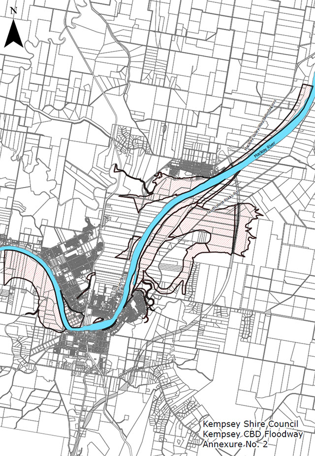
4.1 Kempsey CBD Floodways
A large area of the floodplain is considered floodway. The Kempsey CBD Floodway comprises of the following:
- Kempsey CBD Floodway No. 1, and
- Kempsey CBD Floodway
Refer to Annexure No. 1 and Annexure No. 2 to this Chapter.
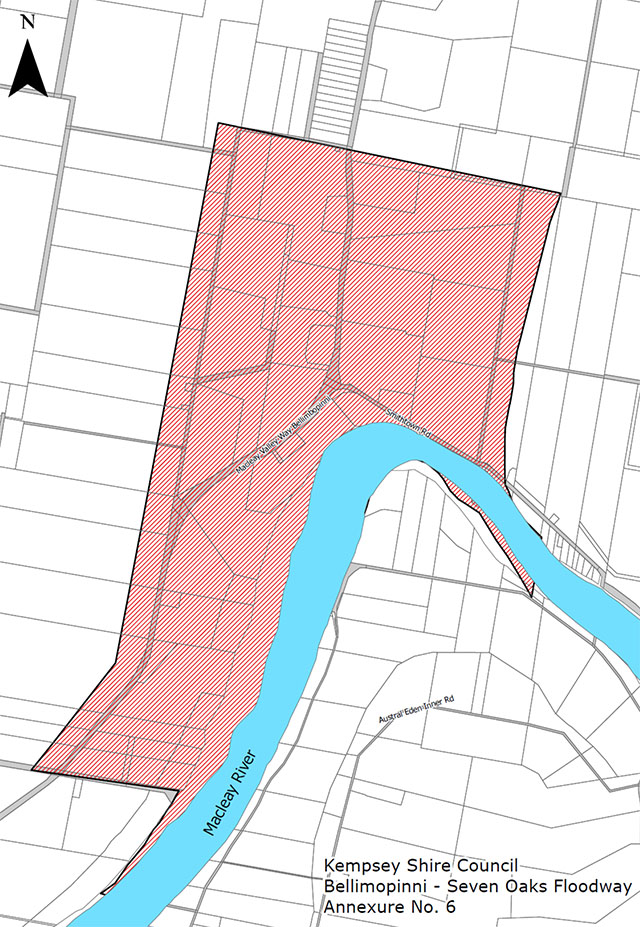
Bellimbopinni/Seven Oaks Floodway
Annexure No. 6 to this Chapter, “Kempsey Shire Floodway Plans – Sheet No. 2”.
Note: The area between the Macleay River and South West Rocks Creek at New Entrance comprising former Lots 850 and 851 DP790816 exhibits floodway characteristics. Any development proposal for this land will require the submission of a detailed flood study.
5 - Flood Precincts - Identified Areas
The following flood precincts have been identified and maps depicting the broad boundaries of these flood precincts are attached as Annexures to this Chapter. These maps are subject to review.
6 - Development Requirements
Desired Outcomes
DO1 - Development appropriately addresses the constraints of flood prone land.
DO2 - Development is undertaken in accordance with the requirements of the relevant Council Policies, guidelines and Floodplain Risk Management Plans addressing development in flood prone areas.
DO3 - Development complies with the recommendations contained in any Council Floodplain Risk Management Plan.
DO4 - On-site Sewerage Management Systems are sited and designed to withstand flooding conditions (including consideration of structural adequacy, avoidance of inundation, and flushing/leaking into flowing flood waters) to a reasonable degree.
DO5 - The habitable floor levels of residences are located at the appropriate residential Flood Planning Level for the site.
DO6 - Development does not have a significant impact on the natural conveyance of floodwaters through Floodways.
DO7 - Development controls for vulnerable types of developments (eg aged care, schools etc) located in the low flood risk (above 1% AEP Flood) parts of the Macleay River Floodplain ensure the safety of people and ensure an Evacuation Plan is in place, appropriate emergency response provisions are provided and a Flood Response Assessment Plan is prepared.
DO8 - Development controls for any critical emergency response and recovery facilities developments located in a low risk flood prone area (above the 1% AEP Flood) on the Macleay River Floodplain ensure continued operation during and after flood events up to and including the PMF.
6.1 On-site Sewage Management Systems
- All components of on-site sewage management systems, including vents, openings and electrical components are to be located above the 1% AEP probability flood contour; except
- Land application/disposal areas for treated effluent may be below the 1% AEP probability flood contour but must be above the 5% AEP probability flood contour.
Note: The figures used in this requirement are taken from the “Environment and Health Protection Guidelines - On-site Sewerage Management for Single Households (NSW Government, January 1998)” and AS/NZS 1547:2012 - Onsite domestic wastewater management.
6.2 Evacuation Planning
New developments must demonstrate that the development will not place additional strain on emergency services.
6.3 Emergency Response Provisions
(a) Essential Community Facilities and Critical Services
Critical infrastructure and emergency services facilities in all locations shall comply with the following:
New Development:
All new critical infrastructure and facilities to be located above PMF level, unless exceptional circumstances can be justified, such as servicing existing flood prone communities where no practical alternative exists. In such cases, and where the development is a habitable land use, adequate PMF refuge must be provided.
Existing Development:
Minor expansion of existing facilities permitted without consideration of PMF. Major expansion below PMF subject to provision of adequate PMF refuge, where the development is a habitable land use.
Note: The PMF refuge must meet the following requirements:
- Refuge must be above the PMF level. PMF levels can be determined from the Flood Planning maps. (NB. If no PMF identified, contact Council for further advice).
- Minimum floor level to be PMF level. No freeboard required.
- For extensions to new facilities, minimum floor area of refuge to be no less than 50% of the incremental increase in total floor area located below the PMF due to the extension, or an equivalent area that would comfortably accommodate and service the needs of occupants for a period of not less than one week.
- Refuge must comply with BCA requirements, with external components rated appropriately for storm, wind and moisture.
- Permanent internal access via permanent staircase, minimum 1.2m wide.
- External access to the refuge must also be provided. Access must remain unobstructed for emergency access during flooding (i.e., clear of trees, services).
- Refuge must have natural lighting and ventilation.
- Support structures below PMF level must be capable of withstanding flood forces (water flow, debris impact, and buoyancy) and continuous submergence for up to one week, requiring an engineering certification.
- Refuge must meet all planning and building controls applicable to the site.
- All services provided as part of normal operations are to be continued undiminished during all flood events. This includes food, water, shelter, power via back-up generators, medical services and hygiene of residents and facilities. All excess sewage, food and medical waste is to be collected and stored until such time as normal disposal can be undertaken. Facility management must make provision for staff to be rostered on and accommodated for the flood period. All such measures must be detailed in the development’s Flood Response Assessment Plan.
b) Habitable Development
New habitable development in all localities shall comply with the following development controls:
i. Sensitive Development, such as residential care facilities, group homes, accommodation for people with a disability.
New Development:
All new sensitive development to have permanent high-level road evacuation route(s) to land above PMF level and/or adequate PMF refuge, subject to the recommendations of an acceptable Flood Response Assessment Plan.
Note: Evacuation of occupants is the preferred risk management approach for sensitive developments proposed below PMF level. Adoption of evacuation as the risk management response for a development requires a Flood Response Assessment Plan that specifically addresses the following evacuation requirements:
- Typical demographics of evacuees (age, gender, etc.).
- Typical medical conditions and/or disabilities of evacuees.
- Mode of transportation.
- Intended evacuation destination.
- Level of service provided by evacuation centre.
- Required staffing for evacuation centre to cater for evacuees.
- Special supply measures for evacuation centre to cater for evacuees (food, water, medical supplies, etc.).
If the above requirements are not able to be met for all future occupants of the development, a PMF refuge shall be provided in accordance with design criteria for existing sensitive development.
Existing Development:
Minor expansion of existing facilities permitted without consideration of PMF. Major expansion below PMF level subject to provision of adequate PMF refuge.
Note: The PMF refuge must meet the following requirements:
- Refuge must be above the PMF level. PMF levels can be determined from the Flood Planning maps. (NB. If no PMF identified, contact Council for further advice).
- Minimum floor level to be PMF level. No freeboard required.
- For new facilities, minimum floor area of refuge to be no less than 50% of the incremental increase in total floor area located below the PMF due to the extension, or an equivalent area that would comfortably accommodate and service the needs of occupants for a period of not less than one week. For extensions to new facilities, minimum floor area of refuge to be no less than 50% of the incremental increase in total floor area located below the PMF due to the extension.
- Refuge must comply with BCA requirements, with external components rated appropriately for storm, wind and moisture.
- Permanent internal access via permanent staircase, minimum 1.2m wide.
- External access to the refuge must also be provided. Access must remain unobstructed for emergency access during flooding (i.e., clear of trees, services).
- Refuge must have natural lighting and ventilation.
- Support structures below PMF level must be capable of withstanding flood forces (water flow, debris impact, and buoyancy) and continuous submergence for up to one week, requiring an engineering certification.
- Refuge must meet all planning and building controls applicable to the site.
- All services provided as part of normal operations are to be continued undiminished during all flood events. This includes food, water, shelter, power via back-up generators, medical services and hygiene of residents and facilities. All excess sewage, food and medical waste is to be collected and stored until such time as normal disposal can be undertaken. Facility management must make provision for staff to be rostered on and accommodated for the flood period. All such measures must be detailed in the development’s Flood Response Assessment Plan.
ii. Residential Development
New Development (except caravan parks and moveable dwellings):
All new development to have permanent high-level road/pedestrian evacuation route(s) to land above PMF level and/or adequate PMF refuge, subject to the recommendations of an acceptable Flood Response Assessment Plan.
Note: Evacuation of occupants is the preferred risk management approach for residential developments below PMF level. Adoption of evacuation as the risk management response for a development requires a Flood Response Assessment Plan that specifically addresses the following evacuation requirements:
- Expected number of occupants/evacuees
- Typical demographics of evacuees
- Mode of transportation
- Intended evacuation destination
- Level of service provided by evacuation centre
- Any special requirements for evacuation centre to cater for evacuees.
If the above requirements are not able to be met for all future occupants of the development, a PMF refuge shall be provided in accordance with existing residential development.
Existing Development (except caravan parks and moveable dwellings):
Minor expansion of existing facilities without consideration of PMF. Major expansion below PMF level must meet new development criteria.
Note: Where PMF refuge is required, the refuge must meet the following minimum requirements:
- Refuge may be an additional second storey, mezzanine level or other raised refuge area above the PMF level. Minimum floor level to be PMF level. No freeboard required. PMF levels can be determined from the Flood Planning maps. (NB. If no PMF identified, contact Council for further advice).
- Minimum floor area for a refuge is 9m² based on a single bedroom occupancy. Add 4m² for each additional bedroom.
- For unit developments, may provide separate refuges within each unit, size in accordance with the above bedroom ratio. Alternately provide a communal refuge, accessible internally by all units, floor area no less than 50% of total floor area located below PMF level, or an equivalent area that would comfortably accommodate and service the needs of the occupants for a period not less than one week.
- Refuge must comply with BCA requirements, with external components rated appropriately for storm, wind and moisture.
- Minimum floor to ceiling/roof frame height in accordance with BCA.
- Refuge must be provided with permanent internal and external access.
- The external access must be unobstructed (by trees, chimneys, aerials, etc.) for emergency boat access during flooding.
- Refuge must have natural lighting and ventilation.
- Support structures below PMF level must be capable of withstanding flood forces (water flow, debris impact and buoyancy) and continuous submergence for up to one week, requiring an engineering certification.
- Refuge must meet all planning and building controls applicable to the site.
- Refuge must have cupboard storage area for flood emergency kit to service all residents with provisions for isolation for up to one week. All such measures must be detailed in the development’s Flood Response Assessment Plan.
New caravan park development:
All new caravan parks and moveable dwelling sites are to have permanent high level road evacuation route(s) to land above PMF level.
Development of existing caravan parks:
No expansion of existing facilities by the addition of moveable dwelling sites permitted, unless permanent high level road evacuation route to high land external to the site is available, or high land internal to the site can be accessed by the additional sites via road and/or pedestrian routes. Expansion of caravan park amenities and other non-habitable facilities permitted without consideration of PMF.
iii. Residential Subdivisions
New subdivisions:
All new subdivision to have high level road evacuation route(s) to land above PMF level, accessible to all allotments via (as a minimum) pedestrian access at or above design flood level not exceeding 100m in length.
6.4 Floodways
6.4.1 Kempsey CBD Floodway No. 1
Council’s aim is to seek the eventual clearance of Kempsey CBD Floodway No. 1 (Annexure 1), but it is recognised there may be circumstances where it is appropriate for Council to consider repairs or renovations to existing buildings. In such cases the following will apply:
- Repairs and renovations must not alter the basic structure of the buildings.
- Existing dwellings must not be converted into multi-residential land uses i.e. dual occupancy, secondary dwelling, multi-dwelling housing, etc
- In the case of undeveloped land, no approval for any development of a residential nature will be granted.
- In the case of undeveloped land, approval will only be granted to development which comprises mainly open space with minimal obstructions to the flow of floodwater, and incorporate design features to minimise the chance of loss of life and damage to property, eg. recreation facilities.
6.4.2 Kempsey CBD Floodway (except as described in 6.4.1)
The following provisions apply to development within the Kempsey CBD Floodway (Annexure 2).
6.4.2.1 Existing Development
- Approval may be given to repairs and renovations to existing development within the floodway provided they do not alter the basic structure of the buildings.
6.4.2.2 New Development (Residential)
In the case of new development proposed to be used for residential purposes, the following criteria must be fulfilled:
- Submission of an acceptable Structural Engineer’s Certificate with the development application, or when a condition is applied to a consent prior to issuing of a Construction Certificate, certifying that the building has been designed to withstand the forces created by floodwater and debris loadings anticipated for that area, and indicate any impacts on adjoining buildings and land.
- Habitable rooms are to have a floor level 500mm above the 1% AEP flood level, i.e., the flood planning level.
6.4.2.3 New Development (Commercial)
In the case of new development proposed to be used for commercial purposes:
- Council will seek the provision of part of the floor level of the building to be 500mm above the 1% AEP flood level to facilitate the storage of goods during time of flood. The amount of space above flood level will be one fifth of the floor area (or a greater area if required by Council) to be a minimum of 500mm above the 1% AEP flood level and specifically set aside for storage goods in time of flood.
This requirement may be reduced if an alternative acceptable flood proofing procedure can be demonstrated for the development.
- Submission of an acceptable Structural Engineer’s Certificate to be submitted prior to the issuing of a Construction Certificate certifying that the building has been designed to withstand the forces created by floodwaters and debris loadings anticipated for that area and indicate any impacts on adjoining buildings and land.
In respect to existing caravan parks, Council will need to be satisfied in respect of the following matters:
- A contingency plan to evacuate people and store caravans in time of flood, satisfactory to Council.
- All caravans located on the site are maintained in a mobile condition, annexes and associated structures are not to be of a rigid construction.
- Relocatable homes, Cabins and the like will not be permitted in Caravan Parks on areas that are subject to flooding. In any other area the floor level is to be at or above the flood planning level and meet other relevant provisions of this Chapter.
6.4.3 Other Floodways (Rural Floodways)
In the case of existing development within these floodways the following will apply:
- Approval will be given to repairs and renovations provided they do not alter the basic structure of the buildings concerned.
- Extensions will be permitted where they do not increase the floor area more than 10% of the existing ground floor area as at 25 February 1980.
- Encouragement will be given to owners of existing dwellings to move to more suitable areas, preferably above the 1% AEP flood level, or to lift the dwelling 500mm above the 1% AEP flood level.
- Existing dwellings must not be converted into multi-residential land uses i.e. dual occupancy, secondary dwelling, multi-dwelling housing, etc.
In the case of new dwellings, construction will not be permitted unless it can be shown that the product of the depth and velocity of flow of water during a 1% AEP flood is equal to, or less than, on (1).
A Structural Engineer’s Certificate advising that the structure can withstand the force of flowing floodwaters, including debris and buoyancy forces as appropriate will be required, prior to the issuing of a Construction Certificate.
Council will need to be satisfied that there will be no undue risk of loss of life or damage to property during such a flood. The depth of flow is to be related to the “natural surface”. The habitable floor levels of any dwelling approved under this Clause must be at least 500mm above the 1% AEP flood level for the site.
Council may make an exception in the case of replacement of an existing dwelling house used in conjunction with a legitimate agricultural use of the land. In many instances it would be appropriate to provide a mound for such a replacement dwelling.
Barns, diaries and other substantial rural buildings are not to be located in floodways.
Former Lots 5 and 6, DP 1022342 and Lot 851 DP790816 at New Entrance, South West Rocks, are considered to be within a probable floodway. Any development proposal for this land will require a detailed flood study to be undertaken.
6.4.4 Subdivision in Floodways
The subdivision of land will not be permitted, other than for boundary adjustments and development which must be located in close proximity to waterways. Such development might include oyster depuration plants and water-based tourist facilities.
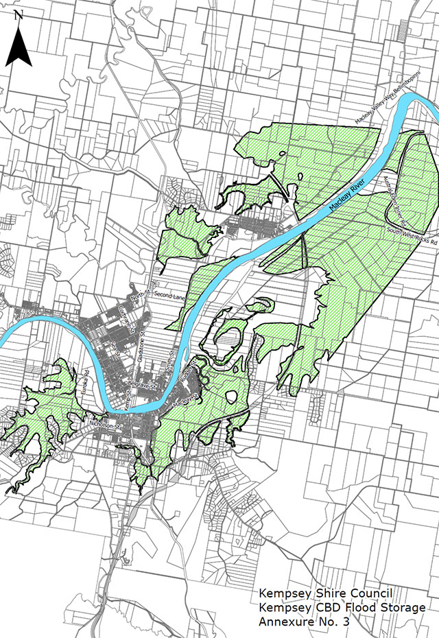
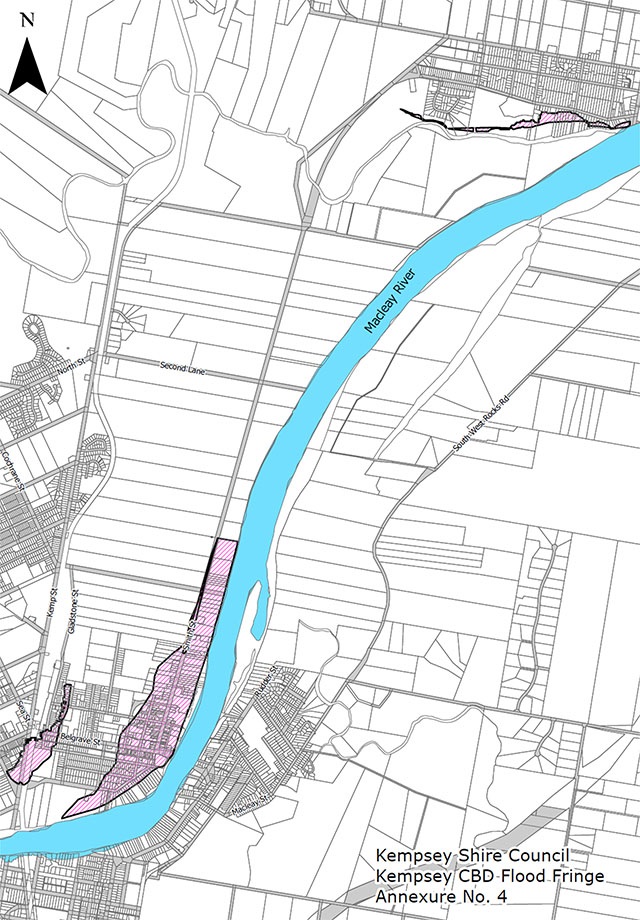
6.5 Flood Precincts
6.5.1 Kempsey CBD Flood Storage, Flood Fringe and Backwater Area
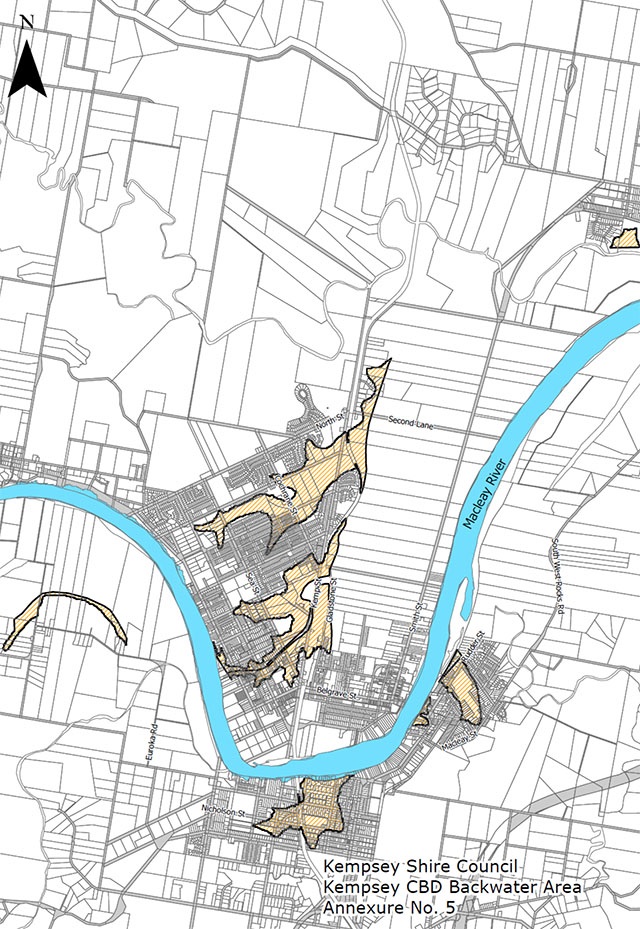
The following provisions apply to development within the Kempsey CBD Flood Storage Area (Annexure 3), Flood Fringe Area (Annexure 4) and Backwater Area (Annexure 5).
6.5.1.1 Existing Development (Residential Extensions less than 10%)
- Approval will be given to repairs and renovations provided they do not alter the basic structure of the buildings. No increase in occupancy is permitted in the Kempsey CBD Flood Storage area.
- However, extensions will be permitted where they do not increase the floor area more than 10% of the existing ground floor area of the development as 25 February 1980. Open verandahs, patios and the like will not be included in the 10% calculations.
6.5.1.2 New Development (Residential and Residential Extensions greater than 10%)
In the case of new development (or extensions to existing development greater than 10% of the ground floor area as of 25th February 1980), proposed to be used for residential purposes the following criterion applies:
- Submission of an acceptable Structural Engineer’s Certificate with the development application, or when a condition is applied to a consent prior to issuing of a Construction Certificate, certifying that the building has been designed to withstand the forces created by floodwater and debris loadings anticipated for that area, and indicate any impacts on adjoining buildings and land.
- Habitable rooms are to have a floor level 500mm above the 1% AEP flood level, i.e., the flood planning level.
6.5.1.3 New Development (Commercial and Commercial Extensions greater than 10%)
- In the case of new development proposed to be used for commercial purposes or extensions to existing development greater than 10% of ground floor area, Council will seek the provision of part of the floor level of the building to be 500mm above the 1% AEP flood level to facilitate the storage of goods during time of flood. The amount of space above flood level will be determined having regard to the size of the extension. In the case of new buildings Council will require one fifth of the floor area (or a greater area if required by Council) to be a minimum of 500mm above the 1 % AEP flood level and specifically set aside for storage of goods in time of flood.
- This requirement may be reduced if an alternative acceptable flood proofing procedure can be demonstrated for the development.
- Commercial development comprising of residential uses within the Flood Fringe must demonstrate that the development will not place additional strain on emergency services within a Flood Response Assessment Plan outlining evacuation of residents.
In respect to existing caravan parks, Council will need to be satisfied in respect of the following matters:
- Submission of an acceptable Structural Engineer’s Certificate prior to the issuing of a Construction Certificate, certifying that the building has been designed to withstand the forces created by floodwaters and debris loadings anticipated for that area, and indicate any impacts on adjoining buildings and land.
- A contingency plan to evacuate people and store caravans in time of flood, satisfactory to Council.
- All caravans located on the site are maintained in a mobile condition, annexes and associated structures are not of a rigid construction.
- Relocatable homes, Cabins and the like will not be permitted in Caravan Parks on areas that are subject to flooding. In any other area the floor level is to be at or above the flood planning level and meet other relevant provisions of this Chapter.
6.6 Flood Prone Lands (Except as described in 6.4 and 6.5)
6.6.1 Urban Development (Residential)
- The difference between the 1% AEP flood level and natural ground level should not be more than 2.5m.
- The floor level of habitable rooms are in accordance with the Council’s adopted floor levels.
- Filling or raising the site levels will require Council consent and will be restricted to locations where the effect on flood patterns is considered minimal and there is likely to be no adverse effect on nearby land.
- A Structural Engineer’s Certificate advising that the structure can withstand the force of flowing floodwaters, including debris and buoyancy forces as appropriate will be required.
- Where the land is part of a Council approved subdivision, the building is to be located on the flood free area as indicated on the plan of subdivision. No additional filling will be permitted.
- Where a building is of two (2) storeys and the ground floor is below the FPL, only rooms not designed for or capable of being used or adapted as habitable rooms will be permitted in the lower floor area.
6.6.2 Rural Development (Residential)
Council’s aim is to restrict rural dwellings in flood prone areas to a minimum by only approving of:
- Dwellings on land where the product of the depth and velocity of flow of water during a 1% AEP flood, is equal to or less than 1.
- Managers or employees’ dwellings approved in accordance with KLEP 1987.
Council will need to be satisfied:
- That a Structural Engineers Certificate advising that the structure can withstand the force of flowing floodwaters, including debris and buoyancy forces as appropriate has been provided.
- That the dwelling is to be erected on the highest practical area within the parcel or lot.
- That the difference between the 1% AEP flood level and natural ground level is not more than 2.5m. A survey certificate may be required to demonstrate compliance with this clause.
- That the floor level of habitable rooms shall be as specified in Section 7 or in accordance with the latest available flood modelling for the area.
- That if the dwelling is proposed to be sited on an earth mound, the mound will extend 4m outside the extremities of the dwelling, contain storage area for at least one vehicle and be constructed of material compacted and battered to slopes of 1 in 5 to withstand flood damage.
- That suitable access from a building to a public road is provided.
- Where a building is of two (2) storeys and the ground floor is below the FPL, only rooms not designed for or capable of being used or adapted as habitable rooms will be permitted in the lower floor area.
- That the building is to be erected on the 1000m² of land identified in the plan of subdivision, which is above the 1% AEP flood level.
6.6.3 Other Development
Each application will be treated on its merits, and Council will consider the development providing such development incorporates mainly open space and adequate flood-proofing measures.
In respect to existing caravan parks, Council will need to be satisfied in respect of the following:
- A suitable Flood Response Assessment Plan exists to evacuate people and store caravans in time of flood.
- The caravans located on the site are maintained in a mobile condition. Annexes and associated structures are not to be of a rigid construction.
- Relocatable homes, Cabins and the like are not permitted on caravan parks on areas that are subject to flooding. In any other area the floor level is to be at or above the flood planning level and meet other relevant provisions of this Chapter.
6.6.4 Renovations to Existing Buildings
- Where any building in flood prone areas within Kempsey Shire is proposed to be raised, the minimum floor level of habitable rooms shall be as specified in Section 7 or in accordance with the latest available flood modelling for the area.
- Additions to existing buildings require a Structural Engineer’s Certificate indicating that the structure can withstand the force of flowing floodwaters restricted to a floor area not exceeding 10% of the ground floor area of the existing building or 20m², whichever is the greater. Open verandahs, patios and the like are not to be included in the calculation. First floor additions will be unrestricted in area provided that this floor level is at a minimum level as specified in Section 7 or in accordance with the latest available flood modelling for the area. A Structural Engineer’s Certificate being provided which indicates that the structure can withstand the force of flowing floodwaters including debris and buoyancy forces as appropriate.
- Renovations such as re-cladding, brick veneering or re-roofing, may be carried out subject to council’s approval where necessary.
6.6.5 Urban Subdivisions
- When land is within the Flood Planning Area, subdivisions will not be approved unless contour surveys of land by a Registered Surveyor or qualified Engineer show that at least 500m² of each proposed lot will be above the 1% AEP or highest flood level.
- The 500m² identified in the subdivision is to be utilised for the erection of buildings on the site.
- In respect to the villages, subdivisions may be permitted provided that it can be shown that the product of the depth and velocity of flow waters during a 1% AEP flood is equal to, or less than one (1) and suitable and adequate arrangements can be made for evacuation).
If filling is to be considered, the maximum depth of filling is not to exceed 1 metre.
6.6.6 Rural Subdivisions
Subdivision to create additional rural lots will not be allowed unless it can be shown:
- That the subdivision is located in the highest practical area of the land to be subdivided.
- That there is an area of at least 1,000m² in the created and residual lots that is not more than 2.5 metres below the assessed 1% AEP flood or the highest flood level for that area and it can be shown that the product of the depth and velocity of flow of waters during a 1% AEP flood is equal to, or less than, one (1).
- The 1000m² identified in the subdivision plan is to be suitable and utilised for the erection of buildings on the site.
- The subdivision of lots in excess of 40 ha will be permitted, but approval to erect a dwelling on any lot so created will not be given unless it can be shown that the product of the depth and velocity of flow of water during a 1% AEP flood is equal to, or less than, one (1).
- Excavations, drainage areas and the like are not to adversely impact on the flood levels on adjoining properties.
- Subdivisions will not be permitted within defined floodways except for boundary adjustments and consolidations where no new dwelling entitlement would occur.
7 - Minimum Floor Levels - Flood Planning Levels (FPL)
The minimum habitable floor levels must be as per Council’s adopted Flood Planning Levels. These levels may be varied from time to time on information obtained from studies undertaken by or on behalf of Council.
To determine the minimum habitable floor level, a Flood Search(PDF, 63KB) is required to be applied for with Council.
All levels are in metres to Australian Height Datum.
Note: Council has adopted interim levels pending completion of the Lower Macleay Flood Risk Management Plan for the Lower Macleay Floodplain and coastal estuaries. Refer Annexure 7.
7.1 Rural Flood Prone Land
The minimum habitable floor levels of dwellings erected on such land shall be 500mm above the 1% AEP flood level as determined by the Director of Operations and Planning and shown on plans available at Council offices.
8 - Floodproofing
8.1 Earth Mounds
When the method of flood proofing a building is to elevate the structure on an earth mound it shall have a minimum crest level equal to the 1% AEP flood applicable and extending a minimum of 4m beyond the dwelling or structure. The habitable floor level to be at a minimum level of 500mm above the 1% AEP flood level.
The mound is to be constructed of compacted earth material able to withstand flooding, with side batters a maximum of 1 in 5.
In rural areas where development may be subject to isolation in times of flood it is desirable that flood free storage areas are available for such items as motor vehicles, plant and equipment. Under exceptional circumstances Council may in rural areas, permit alternative methods of flood proofing such as that specified below.
8.2 Elevated Buildings
Where earth mounds are not appropriate, for example, where they adversely affect the behaviour of flood flows by concentrating and diverting floodwaters to adjacent development, the building shall be supported on piers, columns or piles to enable floodwater to pass beneath. Enclosed stairways and laundries may be acceptable at ground level provided they do not exceed 10m² in area. The structure shall be designed by a practising Structural Engineer to ensure that all structural members will withstand the forces created by floodwater and debris.
8.3 Electrical Installations
Electrical switchboards and fixed electrical installations should be located at a minimum level of 500mm above the 1% AEP flood level; electrical circuits to areas below flood level should be separated from circuits serving areas above flood level. In the case of dairies located in flood prone lands, refrigeration and milk storage facilities should be located at a minimum level of 500mm above the 1% AEP flood event.
8.4 Building Materials
All building materials used at or below Council’s FPL should be constructed of flood compatible materials. All materials used below Council’s FPL must not be susceptible to water damage. Refer to Annexure 8 for flood compatible materials.
9 - Development Applications
9.1 Flood Statements
Flood Statements may be required in respect of developments where Council determines that it does not have sufficient flooding information.
Flood Statements are to be prepared by a Registered Surveyor and based on measured data will generally be acceptable to Council.
Contact Council to determine if a flood statement is required.
9.2 Site Plans
If the contour plan submitted in conjunction with the plans of the proposed building indicates:
- That the building is on flood prone land and that the finished floor level is likely to be within 300mm of the minimum set by this plan, Council shall require a Surveyor’s Certificate certifying the level of the finished floor when the building reaches floor level.
- That the building is proposed to be located in an identified floodway Council shall ask for Structural Engineer’s Certificate certifying that the building has been designed to withstand the forces created by floodwaters and debris loading anticipated for that area and indicate any impacts on adjoining buildings and land.
10 - Miscellaneous
10.1 Structural Engineer’s Certificate
Where an application is for a new building on land within the Flood Planning Area and where the depth of inundation is greater than 0.8m, Council will require a Certificate from a Structural Engineer advising that the building has been designed to withstand the forces created by floodwaters and debris loading anticipated for that area.
10.2 Raising of Existing Building in Floodway
Where the application is for the raising of an existing building located in a floodway, as defined in Section 6.4, a Structural Engineer’s Certificate will be required.
11 - Section 10.7 Certificates
Section 10.7(2) Certificates will indicate whether the land may be impacted by flooding and subject to flood related development controls. The Certificate will suggest that contact should be made with Council in respect to possible flooding matters.
Variation
Council reserves the right to review, vary or revoke this Chapter which will be reviewed periodically to ensure it is relevant and appropriate.
Annexure No. 1
Kempsey CBD Floodway No. 1
Annexure No. 2
Kempsey CBD Floodway
Annexure No. 3
Kempsey CBD Flood Storage
Annexure No. 4
Kempsey CBD Flood Fringe
Annexure No. 5
Kempsey CBD Backwater Area
Annexure No. 6
Kempsey Shire Floodway Plans
Annexure No. 7
Adopted Flood Levels
Council has adopted these revised flood levels for the Lower Macleay Floodplain and coastal estuaries as interim levels pending completion of the Lower Macleay Flood Risk Management Plan, as detailed below.
| Location |
Existing 1% AEP Flood Level (2004) m AHD |
1% AEP Incorporating 0.91m Sea Level Rise m AHD |
| Macleay River |
| Riverbank between Street No’s. 481-515 Austral Eden Outer Road |
5.13 |
5.13 |
| North west corner of Smithtown village |
5.03 |
5.04 |
| Belmore River Junction |
4.75 |
4.79 |
| North east corner of Smithtown village |
4.52 |
4.60 |
| Fattorinni Island |
4.37 |
4.48 |
| Gladstone Drain Junction |
4.25 |
4.41 |
| Kinchela Creek Junction |
4.16 |
4.33 |
| Jerseyville Bridge |
3.56 |
3.8 |
| Spencerville |
3.55 |
3.79 |
| New Entrance Matty’s Flat |
2.52 |
3.08 |
| Macleay Arm Fishermans Reach |
2.53 |
3.14 |
| Shark Island |
2.30 |
3.18 |
| Hat Head |
| 200m North of Traffic Bridge |
2.10 |
2.97 |
| Hat Head Village |
2.10 |
2.97 |
| Ocean |
2.60 |
3.47 |
| Crescent Head |
| Village East |
2.3 |
2.46 |
| Village West Side |
3.75 |
4.21 (assume rise of 1.46m based upon updated flood modelling undertaken for Killick Creek but at Ocean Boundary Level of 2.6m AHD) |
The variation in the Macleay River at the Belmore River Junction is +40mm, Kinchela Creek junction +170mm, Jerseyville Bridge +240mm, New Entrance +560mm and ocean boundary +880mm.
Annexure No. 8
Flood Compatible Building Materials & Construction Methods
The following is to be used as a guide for flood compatible building materials and construction methods. Use of these materials or methods does not guarantee compliance with the relevant provisions of the BCA relating to the construction of buildings on flood prone land.
| Building Component |
Acceptable Material / Construction Method |
| Flooring and sub-floor structure |
Pier and beam constriction, or
Suspended reinforced concrete slabs |
| External wall structures |
Solid brickwork, blockwork, reinforced concrete or mass concrete |
| Equipment |
All equipment installed below or partially below the FPL should be capable of disconnection by a single plug and socket assembly. |
| Fuel |
Heating systems using gas or oil as a fuel should have a manually operated valve located in the fuel supply line to enable fuel cut-off. |
| Installation |
Heating equipment and fuel storage tanks should be mounted on and securely anchored to a foundation pad of sufficient mass to overcome buoyancy and prevent movement that could damage the fuel supply line. All storage tanks should be vented to an elevation of 500mm above the FPL. |
| Services |
All sewer connections to buildings on land at or below the FPL are to be fitted with reflux valves to prevent backflow of sewage in a flood event. Sewer surcharge gullies must be located above the FPL. |
| Floor covering |
Clay tiles;
Concrete, precast or in situ;
Concrete tiles;
Epoxy, formed-in-place;
Mastic flooring, formed-in-place;
Rubber sheets or tiles with chemical set adhesives;
Silicone floors foremer-in-place;
Vinyl sheets or tiles with chemical set adhesives;
Ceramic tiles, fixed with mortar or chemical set adhesive;
Asphalt tiles, fixed with water resistant adhesives; or
Removable rubber-backed carpet |
| Windows |
Aluminium frame |
| Doors |
Solid panel with water proof adhesives;
Flush doors with marine ply filled with close cell foam;
Painted material construction;
Aluminium or galvanised steel frame. |
| Wall and ceiling linings |
Brick, face or glazed;
Clay tile glaxed in waterproof mortar;
Concrete;
Concrete block;
Steel with waterproof applications;
Stone (natural solid or veneer), waterproof grout;
Glass blocks;
Glass; or
Plastic sheeting or wall with waterproof adhesive. |