Chapter B1: Subdivision
1 - Introduction
1.1 Scope of this Chapter
This Chapter applies principally to the design and construction of new subdivision of all land to which the Kempsey Local Environmental Plan 2013 applies.
1.2 Relationship to Other Chapters of this DCP
The provisions of this Chapter provide general controls for subdivision. The provisions of Chapters included in Parts C, D, E and F of this DCP override the provisions of this Chapter to the extent of any inconsistency.
This Chapter provides general controls for subdivision only.
Site-specific subdivision controls may be found in the Chapters contained in Parts C, D, E and F and these chapters should be reviewed during the preparation of a development application for subdivision.
2 - Chapter Objectives
The objectives of this Chapter are:
- To provide greater detail to subdivision requirements contained in Kempsey Local Environmental Plan 2013 and other Chapters of this DCP.
- To provide greater certainty to developers of the subdivision requirements to be applied in Kempsey.
- To ensure that the potential impacts of all subdivisions and subsequent development take into account of the principles of environmental sustainability.
- To encourage efficient site usage in subdivision design.
- To minimize the construction and servicing costs of infrastructure in a manner that maintains equal access to public infrastructure, given the physical limitations of any one site.
- To ensure that subdivision development employs ameliorating measures sufficient to reduce the impact of development on the existing natural and man-made environments.
- To ensure that rural subdivision reinforces the rural character.
- To ensure that subdivision development is designed to respond to natural hazards and physical constraints, such as bush fire, flooding, landslip, etc.
- To ensure adequate vehicular access from the public road system to each new lot.
- To limit development in the Kempsey Shire to development that complies with the provisions of councils’ Flood Plain Management Strategy Policy.
- To facilitate different subdivision forms and the use of different land title systems which may assist in minimising and managing environmental problems (eg the use of community title to manage areas requiring environmental repair or common drainage or effluent systems).
- To provide a degree of certainty to developers, their agents, consultant Surveyors/Engineers and Civil Contractor as to Council’s minimum requirements for design and construction of civil works.
- To provide guidelines for the preparation of development applications for subdivision.
3 - Guidelines - General
3.1 Relationship to Other Documents
Kempsey Local Environmental Plan 2013 contains certain requirements for subdivision, including minimum lot size based on maps, rather than zones. The development requirements of this Chapter should be addressed in conjunction with the subdivision requirements of KLEP. A copy of KLEP2013 is available on Council’s website.
Some issues associated with the design and construction of subdivision developments are addressed by Council Policies. References to Council Policies will be made throughout this Chapter. A copy of Council Policies is available on Council’s website. The Council Policies applicable to subdivision design are:
- Management Policy No. MPOL-53: Access to Rural Subdivisions;
- Council Policy No. CPOL-29: Provision of Access Roads to Rural Residential Areas Zone 1C in the Kempsey Local Environmental Plan 1987;
- Policy No 1.1: Development Control Policy;
- Procedure No.1.1.5: Subdivision - Building Approvals;
- Procedure No. 1.1.6: Subdivision - Building Alignments;
- Procedure No. 1.1.11: Flood Risk Management;
- Policy No. 3.1: Roads Policy; and
- Policy No. 3.3: Water Supply Policy.
Development Contributions will be triggered by subdivision applications, through:
- Current Section 94 Contribution Plans; and
- Current Section 64 Development Service Plans.
A copy of Council’s Contributions Plans are available on Council’s website and will need to reviewed to determine their applicability to each development application. Current fees and charges may be calculated by applying annual CPI to the listed contribution rate, or by contacting Council.
Detailed engineering design and construction requirements for subdivision are contained in Council’s Engineering Guidelines for Subdivision and Development (copy of which is available on Council’s website). The components of Council’s Engineering Guidelines for Subdivision and Development applicable to subdivision design are:
- DQS: Quality Assurance Requirements for Design;
- D1: Geometric Road Design (Urban and Rural);
- D2: Pavement Design;
- D5: Stormwater Drainage Design;
- D6: Site Regrading;
- D7: Erosion Control and Stormwater Management;
- D9: Cycleway and Pathway Design;
- D11: Water Reticulation;
- D12: Sewerage System; and
- D13: Land and Street Scape Design.
Standard drawings for driveways and other details are available on Council’s website. Reference to these standard drawings will be made throughout this and other Chapters.
3.2 Title Systems for Subdivision
There are three main types of title systems used in New South Wales. These are:
- Deposited Plans (or Torrens Title);
- These are the most commonly used type of title used for subdivision.
- They apply to the traditional or single lot form of subdivision.
- Any buildings or structures erected on the land effectively become part of the land by definition.
- The creation and registration of these parcels is regulated by the Real Property Act 1900.
- Strata Plans; and
- Refer to a subdivision of a parcel of land to allow multiple occupancy and separate ownership of individual units.
- Communal open space areas, common driveways and other common facilities may be included in the common property owned and managed by the “Owners Corporation”.
- Regulated by the Strata Schemes (Freehold Development) Act 1973 or Strata Schemes (Leasehold Development) Act 1986.
- Community Plans
- Depict the development of planning communities of any type where the use of some land is shared.
- Provides for individual ownership of lots and a share of “association property”
- Association property is a lot in the scheme on which community facilities may be erected.
- Association property can include land for roads and driveways, swimming pools and other common facilities.
- A multi-tiered structure is possible through Community, Precinct and Neighbourhood Associations.
- Facilitate development being undertaken in stages.
- All Community Title development applications must include a Management Statement, which sets out the rules and responsibilities for running of the scheme.
- Regulated under the Community Development Act 1989 and the Community Land Development Act 1989.
The most appropriate form of title system should be used depending on the nature of the subdivision.
3.3 The Development Process
Figure B1-1 shown below outlines how the development process works.

Figure B1-1: Flow Diagram – Overall Application Process for Subdivisions
3.4 Types of Development
There are three broad types of development as follows:
- Development that does not require consent.
This category generally applies to developments where Part 5 of the Environmental Planning and Assessment Act 1979 is applicable and/or where the development is defined as exempt pursuant to the provisions contained in any environmental planning instrument.
Kempsey Local Environmental Plan 2013 does not contain any exempt development provisions in relation to subdivision.
The following table summarises the exempt development provisions for subdivision contained in:
- State Environmental Planning Policy (Exempt and Complying Development Codes) 2008;
- State Environmental Planning Policy (Infrastructure) 2008; and
- State Environmental Planning Policy No 4 - Development Without Consent and Miscellaneous Exempt and Complying Development.
The following summary is correct as at February 2013. Please refer to current versions of the SEPPs to determine if any amendments supersede the advice provided in the following table.
Table B1-1: Exempt Development Requirements for Subdivision
| Specified Development |
| Widening a public road. |
A minor realignment of boundaries:
- That will not create additional lots; and
- That will not create the opportunity for additional dwellings; and
- That will not result in one or more lots that are smaller than the minimum size specified in an environmental planning instrument in relation to the land concerned (unless the original lot or lots are already smaller than the minimum size); and
- That will not change the area of any lot by more than 10%; and
- That will not adversely affect the provision of existing services on a lot; and
- That will not result in creation of a lot that depends of use of services provided to, or utilities of, another lot; and
- That will not result in increased bushfire risk to existing buildings.
- Rectifying an encroachment on a lot - for example, rectifying an encroachment under the Building Code of Australia, provided it does not contravene any development standards in KLEP2013.
- Creating a public reserve.
|
| Excising from a lot land that is, or is intended to be, used for public purposes, including drainage purposes, rural fire brigade or other emergency service purposes or public toilets. |
| Consolidation of lots. |
Despite the fact that development may be exempt under the Environmental Planning and Assessment Act 1979, approvals under other Acts, such as the Roads Act 1993, may still be required.
- Development that requires consent
This type of development category deals with either Local Development or State Significant Development and is categorized as either of the following classes pursuant to the provisions of Part 4 of the Environmental Planning and Assessment Act 1979:
- Complying Development
- Integrated Development
- Designated Development
- Advertised Development
The following excerpt from State Environmental Planning Policy (Exempt and Complying Development Codes) 2008 (current as at February 2013) relates to the only form of complying development in relation to subdivisions.
“6.1 Specified complying development
The strata subdivision of a building, other than a dual occupancy, for which development consent or a complying development certificate was granted or issued is, for 5 years from the date the consent or certificate was granted or issued, development specified for this code.
6.2 Development standards
The standards specified for that development are:
- that any development consent or complying development certificate relating to the building, the subject of the subdivision, and granted or issued before 1 January 2011 must require the allocation of parking spaces for each individual dwelling, and
- that the subdivision must not contravene any condition of any development consent or complying development certificate applying to the development.
Integrated development is identifies in Section 91 of the Environmental Planning and Assessment Act 1979.In the case of a development application that indicates on its face that such an approval is required, the application must be forwarded to the relevant approval body within 2 days after the application is lodged.
- Prohibited Development
Prohibited development is listed in the zone assessment tables of KLEP and in various other environmental planning instruments.
4 - Guidelines - Applications for Subdivision
4.1 Pre-lodgement Meeting
Before lodging any application proposal to subdivide land in the Kempsey Shire local government area it is recommended that the applicant approach Council to arrange for a pre lodgment meeting. The main aim of this consultation is to make the applicant aware of the following:
- Legislative requirements both Local and State;
- Application Fees and Charges applicable;
- Whether changes to the sketch plan are required prior to lodging it in final form with the application;
- What supporting documentation is required to be lodged with the application for subdivision;
- Whether Public Utility main extensions to serve each lot in the proposal are required and the likely extent;
- Current rates for Section 94 and Water Management Act 2000 contributions.;
- Fees associated with Council issuing Certificates; and
- Any other relevant matter.
4.2 Application Form
In a circumstance where there is a proposal to subdivide land in the Kempsey Shire local government area and development consent is required, the applicant is to make application on the prescribed form, lodge the specified fee and submit all related details, pursuant to Section 78A of the Environmental Planning and assessment Act 1979. A copy of the Application for Development standard form can be found on Council’s website and is available at the front counter of the Council Civic Centre.
4.3 Information to Accompany a Development Application
The following information should accompany any application for subdivision of land:
- Completed application form and prescribed fee.
- A Fauna and Flora Assessment prepared by an appropriately qualified Ecological Consultant, where relevant.
- An On-site Sewage Management Assessment Report in respect to R5 - Large Lot Residential zoned land, land located in the villages of Stuarts Point and Hat Head and other lots as required - to determine whether effluent can be accommodated onsite in accordance with AS1547-2000.
- A flood Statement prepared by a registered surveyor and or consultant Engineer may need to accompany an application if the subject land is affected by the assessed 1 in 100 year flood event.
- Evidence of an assessment/examination of whether the site contains Aboriginal Objects or Places and other matters as required by Chapter B12 - Aboriginal Heritage, where required.
- Archaeological Assessments will only be required in areas identified on Council’s database where there is likely to be items of Aboriginal and or European cultural significance.
- In circumstances where traffic management issues are likely to be significant, a Traffic Impact Assessment prepared by a recognised Traffic Engineer will be required.
Note: State Environmental Planning Policy (Infrastructure) 2008 requires that where the application proposes:
- to create 50 or more lots on a site with access to, or within 90m of, a classified road; or
- to create 200 or more lots on a site that has access to any other type of road, plus it creates a new public road;
the development application is to be referred to the Department of Roads and Maritime Services (RMS) for comment.
- Three copies of the Plan of Application showing the following:
- Drawn to an appropriate scale, with boundary dimensions, site area, and north point, title description, existing easements, natural drainage lines, vegetation cover (including trees), covenants and restrictions.
- Contours, at intervals to suit the topography of the site and extending into adjoining property. Where the proposal has frontage to an existing council road, level of the road are to be provided.
- A locality map.
- If the land is subject to flooding, the 1 in 100 year flood level is to be clearly marked on the plan.
- The subdivision layout giving the dimensions and area of each allotment, location of roads, footpaths, cycle ways, public reserves, stormwater management.
- Display all existing buildings onsite and on adjoining property, stating use.
- Location of any dams, filled dams, filled areas, contaminated soils onsite or on adjoining property and extent of any acid sulfate soils including depth.
- Proximity to airports, sewage treatment works, main roads, industry both light and heavy. Depending on the proximity, additional information may be required.
- Any other details considered relevant to the proposal.
- Council being the consent authority may request additional information following initial assessment of the development application, in accordance with Section 54 of the Environmental Planning and Assessment Regulation 2000.
- A Statement of Environmental Effects.
- A minor subdivision, with minor environmental impacts, may utilise the Statement of Environmental Effects template attached to Council’s Development Application form.
- Applications for subdivision that are more complex (eg a 20 lot subdivision) than that indicated in the previous point will need to be accompanied by a more comprehensive Statement of Environmental Effects than that provided on Council’s Development Application form.
- A Statement of Environmental Effects must indicate the following matters:
- The environmental impacts of the development;
- How the environmental impacts of the development have been identified;
- The steps to be taken to protect the environment or to lessen the expected harm to the environment;
- Any matter required to be indicated in any guidelines issued by the Department of Planning and Infrastructure;
- A summary of how the proposal complies with any relevant development standards and requirements along with suitable forms of justification for any variations.
4.4 Determination of Development Applications
Council can determine an application by:
- Issuing an approval subject to conditions;
- Issuing a refusal; or
- Issuing a deferred commencement approval.
A conditional approval may require the issue of a Subdivision Construction Certificate.
4.5 Subdivision Construction Certificate
Section 81A(4)of the Environmental Planning and Assessment Act states:
Subdivision work in accordance with a development consent must not commence until:
- a construction certificate for the subdivision work has been issued by the consent authority, the council (if the council is not the consent authority) or an accredited certifier, and
- the person having the benefit of the development consent has appointed a principal certifying authority for the subdivision work, and
- the principal certifying authority has, no later than 2 days before the subdivision work commences:
- notified the consent authority and the council (if the council is not the consent authority) of his or her appointment, and
- notified the person having the benefit of the development consent of any critical stage inspections and other inspections that are to be carried out in respect of the subdivision work, and
- the person having the benefit of the development consent has given at least 2 days' notice to the council, and the principal certifying authority if that is not the council, of the person's intention to commence the subdivision work.
Council cannot append additional conditions to the issue of the Construction Certificate. Therefore the engineering plans must have adequate detail to enable a Certifier to be satisfied with the extent and standard of the works based upon the plans and Council’s Engineering Guidelines for Subdivision and Development.
The following information is required to be lodged with any application for Construction Certificate, in accordance with Part 3 of Schedule 1 of the EPAR:
- The name and address of the applicant.
- A description of the building work or subdivision work to be carried out.
- The address, and formal particulars of title, of the land on which the building work or subdivision work is to be carried out.
- In the case of building work, the class of the building under the Building Code of Australia.
- The registered number and date of issue of the relevant development consent, if consent has already been granted for the proposed development.
- The estimated cost of the development…
- Details of the existing and proposed subdivision pattern (including the number of lots and the location of roads),
- Details as to which public authorities have been consulted with as to the provision of utility services to the land concerned,
- Detailed engineering plans as to the following matters:
- Earthworks,
- Roadworks,
- Road pavement,
- Road furnishings,
- Stormwater drainage,
- Water supply works,
- Sewerage works,
- Landscaping works,
- Erosion control works,
- Copies of any compliance certificates to be relied on.
Note - If the applicant is not the owner of the land and the owner of the land has not previously consented to the making of the application, a statement signed by the owner of the land to the effect that the owner consents to the making of the application.
Note - In addition, a list of the documents accompanying the application should be submitted. An application for a construction certificate for subdivision work must be accompanied by:
- appropriate subdivision work plans; and
- subdivision specifications; and
- the prescribed fee.
Note - Council allows self-certification of construction certificates. For more details, refer to Council Policy No. CPOL-60: Guide for Certification of Civil Engineering Design Work (or current equivalent)
If Council is appointed as the Principal Certifying Authority, the Subdivision Officer shall assess the plans and specifications in association with the development consent conditions issued and Council’s policies. Where plans are to be amended, a schedule will be returned to the designer specifying the nature of the amendments. Once all the requirements and amendments have been complied with, the officer will issue the Subdivision Construction Certificate
In the circumstance that a PCA other than Council is appointed, then separate approval in writing shall be obtained from Council for the design of water and sewer systems.
Once all the conditions specified in the development consent have been met, the applicant will apply for a Subdivision Certificate.
4.6 During Construction
During construction, some of the actions and documents that will be required include:
- Inspections;
- Testings;
- Works-as-Executed Plans;
- Compliance with construction standards.
These matters are addressed in more detail in Chapter B3 - Engineering Requirements for Subdivision and Development.
4.7 Subdivision Certificate
Part 4A Section 109C (1)(d) of the Environmental Planning and Assessment Act 1979 defines a "subdivision certificate", being a certificate that authorises the registration of a plan of subdivision under Division 3 of Part 23 of the Conveyancing Act 1919.
A subdivision certificate must not be issued for a subdivision involving subdivision work except by the principal certifying authority appointed for the carrying out of the subdivision.
A subdivision certificate may be issued:
- In the case of subdivision the subject of development consent, by the consent authority (or by Council, if Council is not the consent authority, if authorised).
- In the case of subdivision that is not the subject of development consent, by the council.
- In the case of subdivision carried out by or on behalf of the Crown or a prescribed person, by the Crown or prescribed person or by any person acting on behalf of the Crown or prescribed person.
- in the case of subdivision of a kind identified by an environmental planning instrument as one in respect of which an accredited certifier may be a certifying authority, by an accredited certifier.
Council requires an application for Subdivision Certificate to be lodged.
4.8 Registration of New Titles
The Council endorsed subdivision certificate will need to be lodged with the NSW Land and Property Information Service to create separate title to each allotment.
5 - Development Requirements – Site Analysis
Desired Outcome
DO1 - Site attributes and constraints are carefully considered during the design phase.
Development Requirements
- A site analysis is required for all development and shall illustrate:
- microclimate including the movement of the sun and prevailing winds;
- lot dimensions;
- north point;
- existing contours and levels to AHD;
- flood affected areas;
- overland flow patterns, drainage and services;
- any contaminated soils or filled areas, or areas of unstable land;
- easements and/or connections for drainage and utility services;
- identification of any existing trees and other significant vegetation;
- any existing buildings and other structures, including their setback distances;
- heritage and archaeological features;
- fences, boundaries and easements;
- existing and proposed road network, including connectivity and access for all adjoining land parcels;
- pedestrian and vehicle access;
- views to and from the site;
- overshadowing by neighbouring structures; and
- any other notable features or characteristics of the site.
- Subdivision layout and design responds to the site analysis
6 - Development Requirements - Subdivision Design - Urban Residential Areas (Zones R1, R3 and RU5)
6.1 Scope of this Section
This section applies principally to the design and construction of new subdivision of all land within the following zones:
- R1 - General Residential;
- R3 - Medium Density Residential; and
- RU5 - Village Zone.
6.2 Roads
Desired Outcomes
DO1 - The road layout for subdivisions:
- provides for flow of through traffic with least disruption;
- establishes a hierarchy of roads in accordance with function and usage;
- provides a variation in alignment to allow for existing natural features and to create interest in the streetscape; and
- provides a network of safe pedestrian and cycle paths.
DO2 - Roads are designed and constructed generally in accordance with Council’s Engineering Guidelines for Subdivision and Development.
Development Requirements
- Applicants will be required to provide fully serviced subdivisions including the provision of a sealed road system with drainage, and kerb and gutter to adequately and safely provide both vehicular and pedestrian access to each allotment.
- The applicant will be required to meet the full cost of kerb and guttering across all road frontages of any subdivision in urban areas except where direct vehicular access is restricted.
- Roads adjoining a reserve are to be provided with kerb and gutter.
- Roads are designed and constructed in accordance with Council’s Engineering Guidelines for Subdivision and Development.
- Road layout is to avoid downhill cul-de-sacs.
6.3 Lot Dimensions and Layout
Desired Outcomes
DO1 - Lots fronting a cul-de-sac have sufficient width at the probable building line to accommodate a residential dwelling.
DO2 - Lots fronting a cul-de-sac have sufficient width at the probable building line to accommodate a typical residential dwelling.
DO3 - Battle-axe lots have an access handle width sufficient to allow the minimum driveway width and to accommodate landscaping along the driveway.
DO4 - Lots are oriented and arranged to:
- maximise solar access to lots and future development;
- reflect reasonable consideration of the impact of topography and aspect to maximise solar access;
- allow flexibility in the siting of future buildings, to allow the location of a dwelling and associated private open space with suitable solar access; and
- minimise potential overshadowing impacts to existing and future development.
DO5 - Lot layouts minimise adverse impacts on views and vistas from public areas and from private properties.
DO6 - No rights-of-carriageway are to be utilised in Greenfield subdivision.
DO7 - Rights-of-carriageway (ROW) are only used in infill subdivision only where:
- there are no adverse environmental or social impacts associated with the ROW; and
- the use of ROW’s is better than alternative access options.
DO8 - Lot size and dimensions accommodate future development (refer to Section 5.1 of Chapter C1 - Residential Development)
Development Requirements
- Allotments facing a cul-de-sac are to have a minimum frontage width of 10m per allotment/dwelling.
Note - Any variation below this requirement will need to be supported by a plan showing how the dwelling will fit on the lot.
- The access handle for battle-axe shaped lots is to have a minimum width of:
- 4m if the side boundary adjoins a reserve; or
- 5m on any other circumstance.
- Battle-axe allotments are discouraged in greenfield development.
- Accessways (handles) shall be sited away from noise and visually sensitive components of existing and future dwelling-houses.
- Right of ways (ROW) are to comply with the following:
- Be located to minimise impacts on the front dwelling; and
- Suitable arrangements are to be provided for the maintenance of the ROW (eg which party will maintain it). These arrangements will be included in the terms of Section 88B instruments applying to the land.
- The design of residential subdivisions incorporates the following principles to maximise solar access:
- Street Layout:
- Align streets east-west and north-south wherever possible;
- Aim for north-south streets within 20 degrees west and 30 degrees east of true north; and
- Aim for east-west streets within 30 degrees south and 20 degrees north of true east.
- Land Use and Densities:
- Concentrate smaller lots on north facing slopes with gradients of less than 15% or adjacent to lightly treed open space;
- Locate larger lots, non-residential uses or public open space where solar access is poor, such as south facing slopes;
- Sloping sites are generally suitable for medium to large lots only; and
- Where significant vegetation is to be retained on the site, the size of the lot may need to be increased to allow solar access.
- Laying out the Lots:
- Lot shape and orientation
- Where streets are within the acceptable orientation range, use rectangular lots;
- Locate as many long lot boundaries as possible within the permissible orientation range;
- Where the street is not within the orientation range, use skewed lots.
- Use the Solar Width Guidelines.
- For east/west oriented lots (ie bearing of one long side within 250 degrees and 300 degrees, street on east or west side) - minimum lot width of 16m;
- For north oriented lots (ie bearing of one long side within 340 and 30 degrees, street on southern side) - minimum lot width of 13.5m; and
- For south oriented lots (ie bearing of one long side with 340 and 30 degrees, street on northern side, note that greater lot widths are to allow for car access to the north) - minimum lot width of 15.5m.
- Street orientation, lot width and rating.
- Locate the narrowest lots on the north side of east-west streets;
- Lots on the south side of east-west streets need to be wider to accommodate car access;
- East-west lots need to be wider unless two storey construction is to be restricted;
- East-west lots can be narrowed if there is a road or open space to the north (eg a corner lot);
- Lots less and 300m² are to be approximately square in shape;
- Lots less than 350m² are to be located on land with less than 10% (1:6) slope across the frontage;
- Lots greater than 450m² are to be capable of containing a building platform rectangle measuring 10m x 15m;
- Lots of 300m²-450m² are to be capable of holding a building platform of 9m x 15m, where the major axis of the block is between 30 degrees east and 20 degrees west of true solar north.
- Slope
- Lots on south facing slopes need more open space to the north to protect solar access while lots on north facing slopes need less open space.
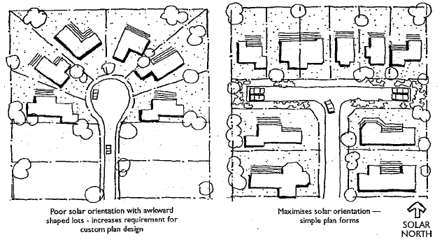
Figure B1-2: Orientation of lots to improve solar access
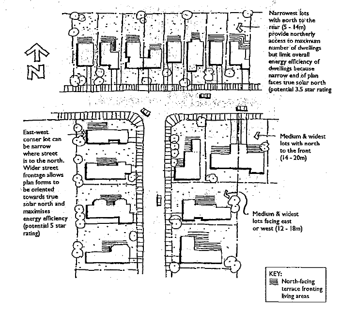
Figure B1-4: Lot width, orientation and street frontage
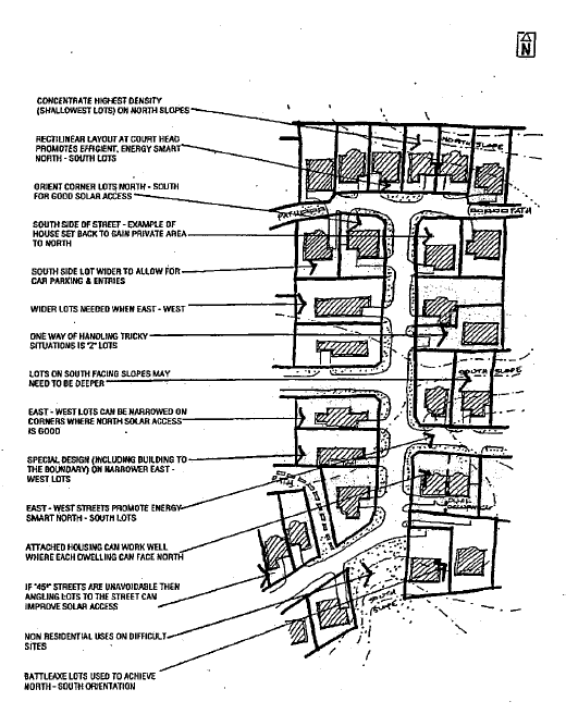
Figure B1-5: Putting all the solar access principles together
6.4 Services and Easements
Desired Outcomes
DO1 - Legal easements of width as determined by the Council Code are to be provided over stormwater drains, watercourses, embankments, cutting that extend into the lots, water supply, sewerage infrastructure and other items as required.
DO2 - Satisfactory arrangements are made for the extension and meeting the costs of providing water and sewer services to and within the subdivision.
DO3 - Satisfactory arrangements are to be made for the provision of electricity and telecommunication services, with these services minimising the impact on the environment and visual amenity of the area, while reducing the cost of provision and maintenance.
DO4 - Services and easements are to be provided generally in accordance with the relevant provisions of Chapter B3 - Engineering Requirements.
DO5 - Sufficient areas are provided within the development for accommodating National Broadband Network (NBN) infrastructure, where relevant.
Development Requirements
- Applicants meet the full cost of water and sewer reticulations within subdivisions plus the cost of connecting to the existing services.
- Electricity services are to be extended to the subdivision in accordance with requirements of the relevant authority and at the full cost of the developer.
- Electricity services are to be provided underground.
- Underground telephone cables, where underground electricity is used, is to be provided by the applicant.
- Telecommunication services are to be provided to each lot.
- Applicants provide a letter from NBN Co (or current equivalent), stating that satisfactory arrangements have been made, prior to the issue of a Subdivision Certificate.
6.5 Stormwater
Desired Outcomes
DO1 - Legal easements of width as determined by the Council Code are to be provided over stormwater drains, lines and related infrastructure.
DO2 - Stormwater management systems are to meet the relevant provisions of:
Development Requirements
- Urban stormwater runoff will need to be assessed in terms of satisfactory performance both within the development and external to the development.
- Downhill cul-de-sacs are not be used in subdivisions. Should a situation arise where a downhill cul-de-sac may be possible, a through road intersecting with the next road downhill, or other road layout arrangement that does not result in increased overland stormwater flow through properties, is to be used instead.
7 - Development Requirements - Subdivision Design - Rural Residential Areas (Zone R5)
7.1 Scope of this Section
This Chapter applies principally to the design and construction of new subdivision of all land within the following zones:
- R5 - Large Lot Residential
7.2 Roads and Access
Desired Outcomes
DO1 - Roads are to be generally designed and constructed in accordance with the relevant Council’s Engineering Guidelines for Subdivision and Development.
DO2 - Access into properties is to be designed and constructed generally in accordance with the relevant parts of Council’s Engineering Guidelines for Subdivision and Development and Standard Drawings.
DO3 - Battle-axe lots have an access handle width sufficient to:
- Accommodate the minimum driveway width;
- Accommodate provision of services; and
- to have no adverse effect on the rural character of the area.
Note - Council Policy No. CPOL-29: Provision of Access Roads to Rural Residential Areas Zone 1C in the Kempsey Local Environmental Plan 1987 includes additional requirements for road access to land within Zone R5.
Development Requirements
- All roads to be provided in accordance with Council minimum requirements as detailed in the relevant design specifications of Council’s Engineering Guidelines for Subdivision and Development.
- Vehicular access to each allotment is to be designed and constructed to comply with ASNZS 2890.1 and Standard Drawing - Standard for Private Vehicle Access from Rural Roads (Plan No. KEMP/R/15/A1).
- All weather 2-wheel drive vehicle access is to be provided from the road to a nominated dwelling site.
- Any access handles used in rural residential lots are to:
- Have a minimum width of 10m; and
- Meet the relevant requirements of Planning for Bushfire Protection 2006.
7.3 Natural Constraints
Desired Outcomes
DO1 - The configuration of the subdivision has consideration for natural features such as rivers, creeks, topography of the land, tree groupings and prominent natural features.
DO2 - Subdivision minimizes impacts on sensitive natural environments.
DO3 - Lot layouts minimise adverse impacts on views and vistas from public areas and from private properties.
Development Requirements
- Subdivision avoids areas considered to be environmentally sensitive, such as estuarine wetlands, rainforests, dunal areas and steep slopes.
- Development for subdivision complies with the relevant provisions of Chapter B10 - Tree Preservation and Vegetation Management.
Note: A Tree Preservation Order applies to all properties.
- An example of how natural constraints may be overcome to the advantage of the development is illustrated below:
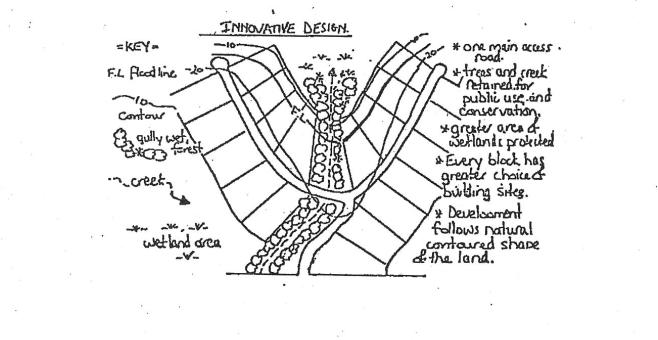
Figure B1-6: Example of overcoming ecological constraint
7.4 Minimum Lot Size and Shape
Desired Outcomes
DO1 - A variety of lot sizes is provided in subdivision developments and within neighbourhoods with the minimum lot size complying with the relevant provisions of KLEP2013.
Development Requirements
- For the purpose of land subdivision in this locality the minimum allotment size permissible is generally one (1) hectare. However, it should be stated, that this does not automatically mean every present allotment or land parcel can be subdivided to the minimum size allowable.
Note - Minimum lot sizes are dictated by the Minimum Lot Size maps forming part of KLEP2013.
- Allotments are to be sized and configured to accommodate the following front boundary setbacks for intended future development of allotments:
- For rural tourist facilities - 45m; and
- For any other building - 18m.
7.5 Frontage to Depth Ratio
Desired Outcomes
DO1 - Lots are designed with a suitable frontage to depth ratio to:
- Accommodate buffers to constraints such as bushfire; and
- To facilitate the use of the allotments for appropriate rural purposes.
Development Requirements
- The ratio of depth to frontage is to be no more than 2 to 1, as illustrated in the following diagram, with the exception of corner lots which may have a depth to frontage ratio of 1 to 1.
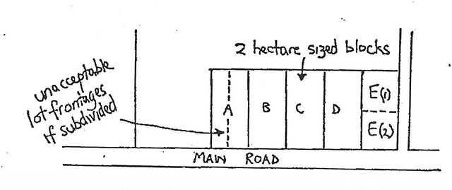
Figure B1-7: Acceptable ratio of lot frontage to lot depth
Allotments 'A' to 'D' inclusive although 2 hectares in size would have unacceptable lot frontages to lot depth ratios as shown on Lot 'A'. However allotment 'E' due to availability of access road off main road could be subdivided with acceptable ratio into one (1) hectare lots 'E' (1) and 'E'(2).
7.6 Services
Desired Outcomes
DO1 - Connection to the sewerage network or the provision of an on-site sewerage management system complies with the relevant provisions of:
DO2 - Suitable easements are provided over sewerage infrastructure within properties.
Development Requirements
- Effluent disposal is normally to be by way of appropriate on-site disposal designed in accordance with AS/NZS 1547-2000: On-site Domestic Wastewater Management.
- However, where the development is in near proximity to an existing sewered area or where in the opinion of the Department of Health or Council's Environmental Services
- An On-site Sewage Management Assessment Report to support sewage treatment proposals is to accompany an application for this type of development.
- Lots are to be designed so that an area remote from any watercourse and downhill of potential home sites is available for effluent disposal.
7.7 Stormwater Management
Desired Outcomes
DO1 - Stormwater management systems are to meet the relevant provisions of:
DO2 - Suitable easements are provided over stormwater infrastructure within properties.
Development Requirements
Nil.
8 - Development Requirements - Subdivision Design - Rural Areas (Zones RU1, RU2, RU3 and RU4)
Rural land is defined as that land other than urban and rural residential. Rural land generally comprises larger holdings zoned rural.
8.1 Scope of this Section
This Section applies principally to the design and construction of new subdivision of all land within the following zones:
- RU1 - Primary Production Zone;
- RU2 - Rural Landscape Zone;
- RU3 - Forestry Zone; and
- RU4 - Rural Small Holdings Zone.
8.2 Frontage to Arterial Road
Desired Outcomes
DO1 - Adequate frontages to main or arterial roads are provided to reduce the number of accesses and potential traffic impacts and the rural character of the area.
Development Requirements
- Where a lot proposed to be created by subdivision has frontage to a main or arterial road, that frontage is not less than 400m.
8.3 Roads and Access
Desired Outcomes
DO1 - An all-weather road system to provide a legal, functional and safe vehicular access to each allotment is provided.
DO2 - Battle-axe lots have an access handle width sufficient to:
- Accommodate the minimum driveway width;
- Accommodate any necessary services; and
- to have no adverse effect on the rural character of the area.
DO3 - A right of carriageway is only used:
- sparingly;
- where they minimise points of conflict on public roads; and
- where the size of the subdivision does not justify establishing a new public road.
DO4 - Access to rural subdivisions are designed/planned to:
- minimise future conflicts over maintenance and access;
- make the burden on the community (eg maintenance) commensurate with the number of potential new rate payers; and
- avoid reliance on non-dedicated public roads (eg Crown and Forestry roads etc).
Development Requirements
- Sealing of the road pavement is required:
- For any new road to be provided in conjunction with the proposed subdivision; and
- For the extension of any road which will be an extension of an existing sealed road.
on all new roads and existing roads which will be an extension of existing sealed roads.
- Minor subdivision in isolated rural areas require all-weather 2 wheel drive access roads suitable for all year round access for essential services (eg school bus, ambulance etc). Each proposal will be assessment on its merits and the following guidelines:
- The status of the road;
- Existing road surface conditions;
- Flooding frequency and hazards of creek or river crossings; and
- Potential population catchment.
- All lots to be created are to have legal access to a dedicated public road.
Note - Crown Roads and Forestry Roads are not “dedicated public roads”. Contact Council for advice should any proposed lots require sole access from a Crown Road or Forestry Road.
- The following requirements apply to a right-of-way (ROW):
- The use of ROWs in rural areas is to be avoided, unless mitigating circumstances require their use.
- The situations where ROWs may be considered are:
- Where an ROW would be used to minimise the number of access points to a main or arterial road, compared to alternative access arrangements.
- Where ROWs are provided, they must be in accordance with the following requirements:
- Must serve no more than three (3) allotments not having dedicated road access;
- Must link directly to an existing or proposed dedicated road;
- Comply with the relevant provisions of Planning for Bushfire Protection 2006;
- The road within the ROW is to be constructed to the standards and requirements of the Rural Fire Service and Council’s Engineering Guidelines for Subdivision and Development;
- Stormwater drainage must not increase overland flows to affected and adjacent properties;
- Be constructed in accordance with the minimum design requirements of Table D1.8 of Development Design Specification D1 - Geometric Road Design of Council’s Engineering Guidelines for Subdivision and Development; and
- Are to be in the form of a “Right of Access”, as defined by the Conveyancing Act 1919, where the conveyance of animals is unlikely but maintenance rights need to be provided or a “right of Carriageway”, where the conveyance of animals is likely to be required.
Note - Council has no obligation or rights for ongoing maintenance of any ROW’s Any ongoing maintenance issues are to be resolved between affects land owners.
- Vehicular access is to be provided to each lot in the subdivision in accordance with Council Standard - Standard for Private Vehicle Access from Rural Roads (Plan No. KEMP/R/15/A1).
8.4 Rural Development Considerations
Desired Outcomes
DO1 - Rural subdivisions are designed to appropriately respond to:
- Satisfactory road access;
- bush fire risk;
- flooding;
- slope and stability of the land;
- adjoining land usage;
- mineral resources; and
- suitabiliity of the land for agriculture.
DO2 - Lot layouts minimise adverse impacts on views and vistas from public areas and from private properties.
Development Requirements
Nil
8.5 Telephone and Electricity
Desired Outcomes
DO1 - Satisfactory arrangements are made for the extension of electricity and telecommunication services to all lots in the subdivision with the relevant authorities.
DO2 - Sufficient areas are provided within the development to accommodate National Broadband Network (NBN) infrastructure, where relevant.
Development Requirements
Nil
9 - Development Requirements - Subdivision Design - Industrial/Commercial Areas (Zones IN1, IN2, B1, B2, B3 and B6)
9.1 Scope of this Section
This Chapter applies principally to the design and construction of new subdivision of all land within the following zones:
- IN1 - General Industrial Zone;
- IN2 - Light Industrial Zone;
- B1 - Neighbourhood Centre;
- B2 - Local Centre;
- B3 - Commercial Centre; and
- B6 - Enterprise Corridor.
9.2 Roads and Access
Desired Outcomes
DO1 - Road design and pavement design caters for heavy traffic conditions.
DO2 - Roads are to be generally designed and constructed in accordance with the relevant Council’s Engineering Guidelines for Subdivision and Development.
Development Requirements
- Vehicular access to each allotment is to be designed and constructed to comply with Council Standard - Standard for Private Vehicle Access from Rural Roads (Plan No. KEMP/R/15/A1).
9.3 Lot Sizes
Desired Outcomes
DO1 - A range of lot sizes catering for the needs of large as well as small developers is provided.
DO2 - Any lot should be large enough for parking and landscaping as well as the specific industrial or commercial use.
DO3 - Commercial and industrial subdivisions comply with the provisions of any relevant area specific chapters of this DCP (refer to Part D).
DO4 - Allotments in commercial and industrial zones are designed to accommodate development that meets the requirements of:
- Chapter C5 - Industrial Development; and
- Chapter C6 - Commercial Development.
Development Requirements
Nil
9.4 Water, Sewerage, Electricity, Telecommunications and Associated Easements
Desired Outcomes
DO1 - Legal easements of width as determined by the Council Code are to be provided over stormwater drains, water supply infrastructure, sewerage infrastructure, watercourses and embankments or cutting that extend into the lots.
DO2 - Satisfactory arrangements are made for the extension and meeting the costs of providing water and sewer services to and within the subdivision.
DO3 - Satisfactory arrangements are to be made for the provision of electricity and telecommunication services, with these services minimising the impact on the environment and visual amenity of the area, while reducing the cost of provision and maintenance.
DO4 - Services and easements are to be provided generally in accordance with the relevant provisions of Chapter B3 - Engineering Requirements.
DO5 - Sufficient areas are provided within the development to accommodate National Broadband Network (NBN) infrastructure, where relevant.
Development Requirements
- Applicants meet the full cost of water and sewer reticulations within subdivisions plus the cost of connecting to the existing services.
- Electricity services are to be extended to the subdivision in accordance with requirements of the relevant authority and at the full cost of the developer.
- Electricity services are to be provided underground, servicing each allotment.
- Underground telecommunication cables, where underground electricity is used, is to be provided by the applicant.
- Telecommunication services are to be provided to each lot.
10 - Development Requirements - Subdivision Design - Natural Hazard Areas
Subdivisions of land susceptible to tidal inundation or coastal erosion are considered Designated Developments and require Environmental Impact Statements in accordance with the Director of the Department of Planning requirements.
10.1 Flood Prone Lands
Desired Outcomes
DO1 - The subdivision of flood prone land complies with the requirements of Council's Floodplain Management Strategy Policy (2003) and the New South Wales Government's Floodplain Development Manual, 2005.
DO2 - Subdivision of residential land (ie Zones R1, R3, R5 and RU5) provides flood free building pads for residential dwellings strictly in accordance with Council’s Flood Risk Management Policy.
DO3 - Subdivision on rural land (ie Zones RU1, RU2, RU3 and RU4) provides suitable building pads for a dwelling and suitable stock holding areas strictly in accordance with Council’s Flood Risk Management Policy.
Development Requirements
- Development will not be allowed to significantly alter flooding patterns.
- Development of internal roads etc. will not be permitted to form significant embankments.
- Subdivision complies with the relevant requirements of Council’s Flood Risk Management Policy.
10.2 Bushfire Protection
Desired Outcomes
DO1 - In bushfire prone land, suitable protection zones and access for fire fighting vehicles and maintenance vehicles so as to minimise the risk of bushfire damage is provided.
Development Requirements
- Subdivision complies with Planning for Bushfire Protection 2006, or the current equivalent.
10.3 Steep and/or Unstable Land
Desired Outcomes
DO1 - The subdivision design responds appropriately to slope stability problems and low strength soils.
DO2 - Appropriate measures are adopted during the construction of subdivisions to avoid soil stability problems.
Development Requirements
- Slope stability issues are given due consideration in the preparation of subdivision layout and design.
- In areas suspected of containing low strength soils which may require special foundation design for future building construction, geotechnical investigation will be required to identify lots so affected.
- Where in the opinion of Council, it is considered that the proposed construction of the subdivision requires further investigation of a geotechnical nature, the developer will be required to submit a geotechnical report prior to the consideration of the subdivision. This report is to be prepared by persons suitably qualified and experienced in the field of Geotechnical investigations.
- A geotechnical report, prepared by a suitably qualified and experienced person, may be submitted with any development application involving natural ground slopes of an excessively steep nature. The geotechnical investigation should address the proposed subdivision works and the proposed building to be erected on the land.
Note - This requirement will not apply where intended future development is not to be located on that part of the site containing excessively steep slopes.
- Any geotechnical report is to take into consideration the implications of site regrading in relation to the existing natural environment.
- Site regrading shall be minimised.
10.4 Acid Sulfate Soils
Desired Outcomes
DO1 - Appropriate management measures are adopted for any acid sulfate soils identified on the land to be subdivided.
Development Requirements
- Acid Sulfate Soil Management Plans are submitted with development applications addressing the relevant requirements of clause 7.1 of KLEP2013.
10.5 Contaminated Land
Desired Outcomes
DO1 - Appropriate investigations are taken for any potentially contaminated land to be subdivided.
DO2 - The subdivision design responds appropriately to any identified contaminated land identified on the site.
DO3 - Appropriate remediation measures are undertaken for any identified contaminated land.
Development Requirements
- Contaminated land investigations are undertaken for sites that have previously been used for any of the activities identified in Table B1-2 below, or that are otherwise identified as being contaminated land.
Table B1-2: Activities that may cause contamination
| Acid/alkali plant and formulation |
| Agricultural/horticultural activities |
| Airports |
| Asbestos production and disposal |
| Banana plantations |
| Chemicals manufacture and formulation |
| Defence works |
| Drum re-conditioning works |
| Dry cleaning establishments |
| Electrical manufacturing (transformers) |
| Electroplating and heat treatment premises |
| Engine works |
| Explosives industry |
| Gas works |
| Iron and steel works |
| Landfill sites |
| Metal treatment |
| Mining and extractive industries |
| Oil production and storage |
| Paint formulation and manufacture |
| Pesticide manufacture and formulation |
| Power stations |
| Railway yards |
| Scrap yards |
| Service stations and fuel depots |
| Sheep and cattle dips |
| Smelting and refining |
| Tanning and associated trades |
| Waste storage and treatment |
| Wood preservation |
- In relation to contaminated land issues, Preliminary Investigations, Detailed Investigations, Remedial Action Plans and Measures for Validation and Monitoring are undertaken in accordance with the following, as relevant:
- State Environmental Planning Policy No.55 - Remediation of Land;
- Contaminated Land Management Act 1997; and
- Managing Land Contamination: Planning Guidelines SEPP 55 - Remediation of Land (Department of Urban Affairs and Planning, Environment Protection Authority, 1998).
11 - Development Requirements - Developer Contributions
Introduction
Council's authority to levy contributions is derived from Section 94 of the Environmental Planning and Assessment Act 1979 (Development Contributions Plans) and Developer Servicing Plans prepared pursuant to the Water Management Act 2000. Accordingly Council's contribution requirements will be in accordance with a "Section 94 Contributions Plan" or a Developer Servicing Plan.
Desired Outcomes
DO1 - Applicants/developers contribute towards the augmentation of local and arterial road works, open space, community, cultural and emergency services and centralized parking where upgrading requirements can be attributed to the development, in accordance with the relevant Section 94 Plans.
DO2 - Applicants/developers contribute to water supply and sewerage head works in accordance with relevant Development Servicing Plans.
DO3 - Where relevant, satisfactory alternatives to paying contributions, in whole or part, are agreed between Council and the applicant/developer. These alternative arrangements include:
- Voluntary Planning Agreements;
- Works in kind; and/or
- Dedication of land.
Development Requirements
Nil
12 - Development Requirements - Crown Roads
Desired Outcomes
DO1 - Suitable arrangements are made for developing Crown Roads and handing the Crown Road over to Council.
Development Requirements
- Prior to any development of a Crown Road, the developer is to liaise with the Department of Trade and Investment (Crown Land).
- Where the Department concurs with the construction of a road within the Crown Reserve, and Council is nominated as the future Road Authority, the road is to be constructed to the standards as outlined in Council’s Engineering Guidelines for Subdivision and Development. Plans and specifications are to be submitted for approval with the development application.
- All fees and costs involved in such construction shall be met by the developer.
13 - Development Requirements - Provision of Local Parks
13.1 General
Desired Outcomes
DO1 - Local parks are provided at a size, location and quality commensurate with the size and nature of the development.
DO2 - An Open Space Management Strategy is submitted with the development application and approved by Council for any proposed local parks.
DO3 - Local parks and Open Space are provided in accordance with any approved Master Plan prepared in accordance with SEPP No 71 - Coastal Protection (Note - there are various triggers for when a Master Plan is required, including where part of a site is within a sensitive coastal location and subdivision of residentially zoned land into more than 25 lots).
Development Requirements
- Where a proposed subdivision is for less than 50 lots, Council prefers payment of contributions, where relevant.
- Where a proposed subdivision is for more than 50 lots, Council will consider dedication of a local park, subject to the following requirements:
- The submission of an Open Space Management Strategy to be approved by Council, including the following:
- A maintenance strategy;
- Identification of the point in the development process that the local park will be handed over to Council; and
- Whether the local park will be developed in stages.
- Where a proposal is for a large scale subdivision (eg 300 lots), an Open Space Management Strategy is to be submitted with the development application and approved by Council.
- For large scale subdivisions, the applicant is to have a pre-lodgement meeting with Council to come to an agreement in relation to the content and details to be included in the Open Space Management Strategy.
Appendices
Appendix A: Summary of Planning Controls
Table B1.3 shown below contains planning controls, which are contained in Councils Kempsey Local Development Plan 1987 and the Flood Plain Management Strategy Policy:
Note: Lot sizes do not correspond directly with the Zone. Minimum lot sizes are determined from the lot size maps included with Kempsey LEP2013.
Table B1.3 - Summary of Planning Controls
| Development |
Standard |
|
|
|
|
| Land-use Zone |
Typical Minimum Lot Area
(check LEP Lot Size Map) |
Reticulated Water Supply |
Sewerage System |
Flooding |
Other |
| R1, R3, RU5 |
500m² |
To each lot |
To each lot |
500m2 Outside limit 1 in 100year flood |
|
| R3 |
800m² |
To each lot |
To each lot |
500m² Outside limit 1 in 100 year flood |
|
| IN2 |
No lot size correlating to zone - Check LEP |
To each lot |
To each lot |
500m² Outside limit 1 in 100year flood |
|
| R5 |
1 ha |
To each lot |
AS 1547-2000 onsite disposal |
1,000m² Outside limit 1 in 100year flood |
|
| R5- Arakoon |
1ha |
Not Required |
AS 1547 - 2000 onsite disposal |
1,000m² Outside limit 1 in 100 year flood |
|
| RU4 |
8ha |
Not Required |
AS 1547-2000 onsite disposal |
|
|
| E2, E3 |
40 Ha |
Not Required |
Not required |
Clause 6.26 of Flood Strategy |
|
| RU1, RU2 |
40Ha |
Not Required |
Not Required |
Clause 6.26 of Flood Strategy |
Minimum frontage to main or arterial road of 400 metres. |
| Note: This Table does not contain details of other planning instruments such as State Environmental Planning Policies, Regional Environmental Plans and or related Acts that affect development in the Kempsey Shire local government area. Therefore it is very important that any applicant arrange to meet with council before submitting an application to obtain information as to how these state policies, plans and Acts may affect the development proposal. |